IMAGES TAKEN NEAR TO
Sarra Lane, CHESTER, CH3 9PA
Introduction
This page details the photographs taken nearby to Sarra Lane, CH3 9PA by members of the Geograph project.
The Geograph project started in 2005 with the aim of publishing, organising and preserving representative images for every square kilometre of Great Britain, Ireland and the Isle of Man.

There are currently over 7.5m images from over14,400 individuals and you can help contribute to the project by visiting https://www.geograph.org.uk
Image Map
Images are licensed for reuse under creativecommons.org/licenses/by-sa/2.0
Notes
- Clicking on the map will re-center to the selected point.
- The higher the marker number, the further away the image location is from the centre of the postcode.
Image Listing (19 Images Found)
Images are licensed for reuse under creativecommons.org/licenses/by-sa/2.0
Image
Details
Distance
1

Sarra Lane at Burwardsley
Waymarker post for path up to Raw Head
Image: © Raymond Knapman
Taken: 25 Mar 2016
0.08 miles
2
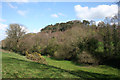
View towards Willow Hill, Burwardsley
View across a valley with a small stream towards the west face of Willow Hill, from the stretch of Sarra Lane running broadly north-south. This side of Willow Hill is covered with mixed woodland, including Scots pines and deciduous trees. The foreground pasture contains gorse bushes
Image: © Espresso Addict
Taken: 1 Apr 2012
0.10 miles
3
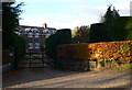
Broad Rough, Burwardsley
I was particularly impressed with the well-clipped yews lining the drive to this house.
Image: © Eirian Evans
Taken: 28 Oct 2009
0.11 miles
4
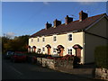
Row of terraced cottages in Burwardsley
Image: © Eirian Evans
Taken: 28 Oct 2009
0.12 miles
5
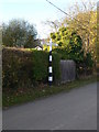
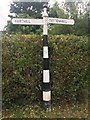
Old signpost in Burwardsley
Signs to Hartill and Tattenhall on the Harthill Road in the centre of the village.
Image: © Eirian Evans
Taken: 28 Oct 2009
0.12 miles
6
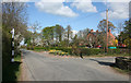
Burwardsley village in early spring
The junction of Harthill Road and School Lane in the pleasant village of Burwardsley. An old-fashioned signpost is visible on the left
Image: © Espresso Addict
Taken: 1 Apr 2012
0.12 miles
7
Direction Sign ? Signpost
Located on the west side of the T junction of Riding Bank and Church Road in Burwardsley parish. 2 arms and pawn finial. See also http://www.geograph.org.uk/photo/1565476.
Milestone Society National ID: CH_SJ5156B
Image: © W MacDonald
Taken: 21 Jun 2020
0.13 miles
8
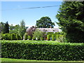
Broad Rough
Whatever else may have prompted the name it is certainly not the gardens that are rough. They're trimmed and topiaried to within an inch of life.
Image: © Peter Turner
Taken: 12 Jun 2010
0.14 miles
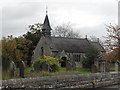
9
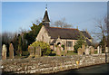
St John's Church, Burwardsley
Grade-II-listed sandstone parish church, dating originally from the early 17th century with late 19th century additions by John Douglas, including the bell turret
Image: © Espresso Addict
Taken: 25 Jan 2009
0.14 miles
10
Church of St John the Divine - Burwardsley
Image: © Anthony Parkes
Taken: 28 Oct 2010
0.15 miles