IMAGES TAKEN NEAR TO
Tattenhall Lane, CHESTER, CH3 9NH
Introduction
This page details the photographs taken nearby to Tattenhall Lane, CH3 9NH by members of the Geograph project.
The Geograph project started in 2005 with the aim of publishing, organising and preserving representative images for every square kilometre of Great Britain, Ireland and the Isle of Man.

There are currently over 7.5m images from over14,400 individuals and you can help contribute to the project by visiting https://www.geograph.org.uk
Image Map
Images are licensed for reuse under creativecommons.org/licenses/by-sa/2.0
Notes
- Clicking on the map will re-center to the selected point.
- The higher the marker number, the further away the image location is from the centre of the postcode.
Image Listing (6 Images Found)
Images are licensed for reuse under creativecommons.org/licenses/by-sa/2.0
Image
Details
Distance
2
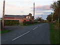
Tattenhall Lane near Newton
Tattenhall Lane heading west, Rose Farm is on the left.
Image: © Jeff Buck
Taken: 9 Aug 2012
0.02 miles
4
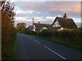
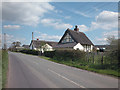
Thatched cottages on Tattenhall Lane
At Spring House Farm.
Image: © Eirian Evans
Taken: 28 Oct 2009
0.13 miles
5
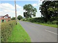
Spring House Farm
Marked on the Ordnance Survey map as a farm it now appears to be residential property set amongst Cheshire farmland on the road joining Beeston Image with Tattenhall. Image
Image: © Dennis Turner
Taken: 29 Apr 2006
0.19 miles
6

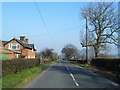
Squarehouse Farm, Tattenhall
Farm with barn conversions on Tattenhall Lane.
Image: © Eirian Evans
Taken: 28 Oct 2009
0.21 miles