IMAGES TAKEN NEAR TO
Bolesworth Road, CHESTER, CH3 9HL
Introduction
This page details the photographs taken nearby to Bolesworth Road, CH3 9HL by members of the Geograph project.
The Geograph project started in 2005 with the aim of publishing, organising and preserving representative images for every square kilometre of Great Britain, Ireland and the Isle of Man.

There are currently over 7.5m images from over14,400 individuals and you can help contribute to the project by visiting https://www.geograph.org.uk
Image Map
Images are licensed for reuse under creativecommons.org/licenses/by-sa/2.0
Notes
- Clicking on the map will re-center to the selected point.
- The higher the marker number, the further away the image location is from the centre of the postcode.
Image Listing (3 Images Found)
Images are licensed for reuse under creativecommons.org/licenses/by-sa/2.0
Image
Details
Distance
1
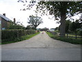
Entrance to Woodlake Farm, Tattenhall
The entrance to Woodlake Farm on Bolesworth Road.
Image: © Jeff Buck
Taken: 7 Sep 2012
0.03 miles
2
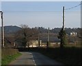
Woodlake Farm, Tattenhall
Looking along Bolesworth Road, Tattenhall towards Woodlake Farm, with the wooded Raw Head viewing point behind. On the far right of the photo is Bolesworth Castle highlighted in the afternoon sun.
Image: © John S Turner
Taken: 6 Apr 2007
0.05 miles
3
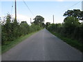
Bolesworth Road
Bolesworth Road heading south west away from Tattenhall.
Image: © Jeff Buck
Taken: 7 Sep 2012
0.07 miles