IMAGES TAKEN NEAR TO
Newton Lane, CH3 9GF
Introduction
This page details the photographs taken nearby to Newton Lane, CH3 9GF by members of the Geograph project.
The Geograph project started in 2005 with the aim of publishing, organising and preserving representative images for every square kilometre of Great Britain, Ireland and the Isle of Man.

There are currently over 7.5m images from over14,400 individuals and you can help contribute to the project by visiting https://www.geograph.org.uk
Image Map
Images are licensed for reuse under creativecommons.org/licenses/by-sa/2.0
Notes
- Clicking on the map will re-center to the selected point.
- The higher the marker number, the further away the image location is from the centre of the postcode.
Image Listing (7 Images Found)
Images are licensed for reuse under creativecommons.org/licenses/by-sa/2.0
Image
Details
Distance
1
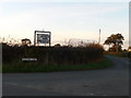
Tempting sign
On the corner of Birds Lane and Newton Lane, Tattenhall.
Image: © Eirian Evans
Taken: 28 Oct 2009
0.04 miles
2
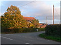
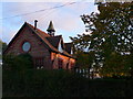
Ebenezer Chapel, Tattenhall
Built in 1851, this chapel stands on the corner of Wood Lane and Tattenhall Lane.
Image: © Eirian Evans
Taken: 28 Oct 2009
0.06 miles
4
Converted Chapel near Newton
Converted chapel on the junction of Tattenhall Lane and Wood Lane.
Image: © Jeff Buck
Taken: 9 Aug 2012
0.06 miles
5
Ebenezer Chapel, Tattenhall
Converted chapel on the corner of Wood Lane and Tattenhall Lane.
Image: © Eirian Evans
Taken: 28 Oct 2009
0.09 miles
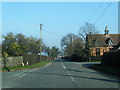
6
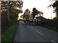
Milking time
Taking the cows to be milked to Lanes Farm.
Image: © Eirian Evans
Taken: 28 Oct 2009
0.09 miles
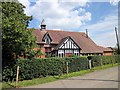
7

Squarehouse Farm, Tattenhall
Farm with barn conversions on Tattenhall Lane.
Image: © Eirian Evans
Taken: 28 Oct 2009
0.21 miles