IMAGES TAKEN NEAR TO
Chapel Lane, CHESTER, CH3 9EE
Introduction
This page details the photographs taken nearby to Chapel Lane, CH3 9EE by members of the Geograph project.
The Geograph project started in 2005 with the aim of publishing, organising and preserving representative images for every square kilometre of Great Britain, Ireland and the Isle of Man.

There are currently over 7.5m images from over14,400 individuals and you can help contribute to the project by visiting https://www.geograph.org.uk
Image Map
Images are licensed for reuse under creativecommons.org/licenses/by-sa/2.0
Notes
- Clicking on the map will re-center to the selected point.
- The higher the marker number, the further away the image location is from the centre of the postcode.
Image Listing (8 Images Found)
Images are licensed for reuse under creativecommons.org/licenses/by-sa/2.0
Image
Details
Distance
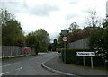
1
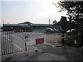
Ambulance Station, Milton Green
Mersey Regional Ambulance Service Trust on Chapel Lane, Milton Green.
Image: © Jeff Buck
Taken: 2 Mar 2012
0.09 miles
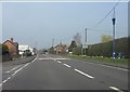
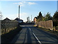
3
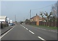
Milton Green - A41 at the car dealership
Image: © Peter Whatley
Taken: 23 Mar 2012
0.17 miles
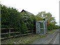

8
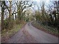
Chapel Lane near Calveley Hall
Chapel Lane is also part of the Bishop Bennet Way long distance footpath.
Image: © Jeff Buck
Taken: 2 Mar 2012
0.22 miles