IMAGES TAKEN NEAR TO
Park Lane, CHESTER, CH3 9BY
Introduction
This page details the photographs taken nearby to Park Lane, CH3 9BY by members of the Geograph project.
The Geograph project started in 2005 with the aim of publishing, organising and preserving representative images for every square kilometre of Great Britain, Ireland and the Isle of Man.

There are currently over 7.5m images from over14,400 individuals and you can help contribute to the project by visiting https://www.geograph.org.uk
Image Map
Images are licensed for reuse under creativecommons.org/licenses/by-sa/2.0
Notes
- Clicking on the map will re-center to the selected point.
- The higher the marker number, the further away the image location is from the centre of the postcode.
Image Listing (5 Images Found)
Images are licensed for reuse under creativecommons.org/licenses/by-sa/2.0
Image
Details
Distance
1
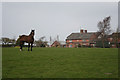
Brereton Park Farm
Looking back from the footpath to Lower Huxley Hall and Hargrave.
Image: © Dave Dunford
Taken: 27 Mar 2011
0.01 miles
2
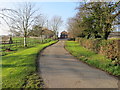
Park Lane ends here at Brearton Park Farm
Looking north-westward.
Image: © Peter Wood
Taken: 17 Nov 2018
0.05 miles
3
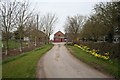
Brereton Park Farm
From the end of the no-through road that ends at the farm entrance; a footpath continues beyond (to the left of this photograph) to Lower Huxley Hall and Hargrave.
Image: © Dave Dunford
Taken: 27 Mar 2011
0.09 miles
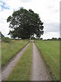
4

Park Lane
A cul-de-sac road leading to Bretton Farm
Image: © David Quinn
Taken: 3 Jul 2010
0.19 miles
5
Driveway to Upper Brookhouse Farm
A private driveway between Upper Brookhouse Farm and Park lane, which also makes up part of a footpath.
Image: © David Quinn
Taken: 3 Jul 2010
0.24 miles