IMAGES TAKEN NEAR TO
Hoofield Lane, CHESTER, CH3 9BP
Introduction
This page details the photographs taken nearby to Hoofield Lane, CH3 9BP by members of the Geograph project.
The Geograph project started in 2005 with the aim of publishing, organising and preserving representative images for every square kilometre of Great Britain, Ireland and the Isle of Man.

There are currently over 7.5m images from over14,400 individuals and you can help contribute to the project by visiting https://www.geograph.org.uk
Image Map (Loading...)


Getting Data...Please wait
Leaflet Map data © OpenStreetMap
Images are licensed for reuse under creativecommons.org/licenses/by-sa/2.0
Notes
- Clicking on the map will re-center to the selected point.
- The higher the marker number, the further away the image location is from the centre of the postcode.
Image Listing (5 Images Found)
Images are licensed for reuse under creativecommons.org/licenses/by-sa/2.0
Image
Details
Distance
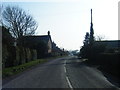
2

Road Junction at Huxley
The junction of Hoofield Lane and Huxley Lane. Huxley Chapel is on the right.
Image: © Jeff Buck
Taken: 9 Jul 2012
0.20 miles
3
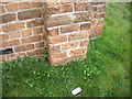
Cut Mark: Methodist Chapel, Huxley
OS Cut Mark in the brickwork of the Methodist Chapel, Huxley. Number B11095 on the Benchmark Database, see http://www.bench-marks.org.uk/bm37449
Image: © VBForever
Taken: 1 Apr 2011
0.20 miles
4
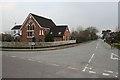
Huxley Chapel
Showing the Hargrave junction on Huxley Lane.
Image: © Dave Dunford
Taken: 27 Mar 2011
0.21 miles
5
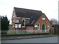
Methodist Jubilee Chapel, Huxley
The chapel was opened for worship in 1860.
Image: © JThomas
Taken: 3 Dec 2016
0.21 miles