IMAGES TAKEN NEAR TO
Hatton Hall Lane, CHESTER, CH3 9AP
Introduction
This page details the photographs taken nearby to Hatton Hall Lane, CH3 9AP by members of the Geograph project.
The Geograph project started in 2005 with the aim of publishing, organising and preserving representative images for every square kilometre of Great Britain, Ireland and the Isle of Man.

There are currently over 7.5m images from over14,400 individuals and you can help contribute to the project by visiting https://www.geograph.org.uk
Image Map
Images are licensed for reuse under creativecommons.org/licenses/by-sa/2.0
Notes
- Clicking on the map will re-center to the selected point.
- The higher the marker number, the further away the image location is from the centre of the postcode.
Image Listing (6 Images Found)
Images are licensed for reuse under creativecommons.org/licenses/by-sa/2.0
Image
Details
Distance
1
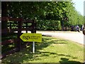
NGS sign Hatton House
The gardens of Hatton House were opened under the National Garden Scheme http://www.ngs.org.uk/
Image: © Norman Caesar
Taken: 5 Jun 2016
0.03 miles
3
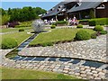
The gardens of Hatton House
These gardens were opened under the National Garden Scheme http://www.ngs.org.uk/
Image: © Norman Caesar
Taken: 5 Jun 2016
0.06 miles
4
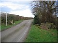
Entrance to Hatton Hall
At this point the public road from the A41 becomes a public footpath past Hatton Hall heading for Hargrave.
Image: © John S Turner
Taken: 21 Jan 2007
0.11 miles
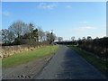
5
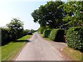
Lane from Hatton House towards Hatton Heath
Image: © Norman Caesar
Taken: 5 Jun 2016
0.12 miles
6
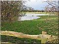
Pond near Hatton Hall
Taken from the footpath that passes Hatton Hall on its way to Hargrave.
Image: © John S Turner
Taken: 21 Jan 2007
0.12 miles