IMAGES TAKEN NEAR TO
Tarporley Road, CHESTER, CH3 8NF
Introduction
This page details the photographs taken nearby to Tarporley Road, CH3 8NF by members of the Geograph project.
The Geograph project started in 2005 with the aim of publishing, organising and preserving representative images for every square kilometre of Great Britain, Ireland and the Isle of Man.

There are currently over 7.5m images from over14,400 individuals and you can help contribute to the project by visiting https://www.geograph.org.uk
Image Map (Loading...)


Getting Data...Please wait
Leaflet Map data © OpenStreetMap
Images are licensed for reuse under creativecommons.org/licenses/by-sa/2.0
Notes
- Clicking on the map will re-center to the selected point.
- The higher the marker number, the further away the image location is from the centre of the postcode.
Image Listing (5 Images Found)
Images are licensed for reuse under creativecommons.org/licenses/by-sa/2.0
Image
Details
Distance
1
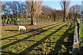
Smallholding!
A strip of land next to a layby on the A51 contained 2 sheep, a cockerel and a lot of dumped rubbish!
Image: © David Marten
Taken: 14 Jan 2007
0.05 miles
3
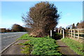
A51 and Adjacent Footpath
Between Tarvin and Duddon Heath the A51 and a footpath are adjacent and parallel.
Image: © David Marten
Taken: 14 Jan 2007
0.13 miles
4
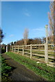
Footpath adjacent to A51
The A51 between Tarvin and Duddon Heath in SJ4965 has a footpath adjacent and parallel to the A road.
Image: © David Marten
Taken: 14 Jan 2007
0.14 miles
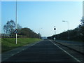
5
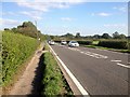
Tarporley Road (A51) Looking East near to Tarvin
Image: © David Dixon
Taken: 7 Sep 2015
0.16 miles