IMAGES TAKEN NEAR TO
High Street, CHESTER, CH3 8JB
Introduction
This page details the photographs taken nearby to High Street, CH3 8JB by members of the Geograph project.
The Geograph project started in 2005 with the aim of publishing, organising and preserving representative images for every square kilometre of Great Britain, Ireland and the Isle of Man.

There are currently over 7.5m images from over14,400 individuals and you can help contribute to the project by visiting https://www.geograph.org.uk
Image Map
Images are licensed for reuse under creativecommons.org/licenses/by-sa/2.0
Notes
- Clicking on the map will re-center to the selected point.
- The higher the marker number, the further away the image location is from the centre of the postcode.
Image Listing (103 Images Found)
Images are licensed for reuse under creativecommons.org/licenses/by-sa/2.0
Image
Details
Distance
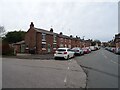
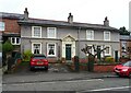
1
Sandstone Cottage, Tarvin
This cottage next to a former church on the main street in Tarvin stands on a plinth of sandstone bedrock.
Image: © Dave Dunford
Taken: 10 Jan 2010
0.01 miles
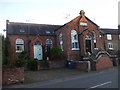
2
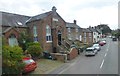
The Methodist Chapel on High Street, Tarvin
Image: © Raymond Knapman
Taken: 26 Sep 2013
0.02 miles
3
The former Zion Primitive Methodist Chapel, Tarvin
Image: © John Lord
Taken: 8 Feb 2011
0.02 miles
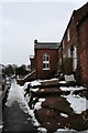
4
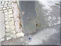
Cut Mark on Gatepost, Tarvin High Street
OS Cut Mark on Gatepost, Tarvin High Street. Number B10688 on Benchmark Database, see: http://www.bench-marks.org.uk/bm36942
Image: © VBForever
Taken: 11 Feb 2011
0.03 miles
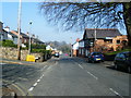
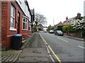
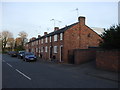
8
High Street in Tarvin
Looking north-eastward.
Image: © Peter Wood
Taken: 17 Nov 2018
0.04 miles