IMAGES TAKEN NEAR TO
Long Lane, CHESTER, CH3 7RB
Introduction
This page details the photographs taken nearby to Long Lane, CH3 7RB by members of the Geograph project.
The Geograph project started in 2005 with the aim of publishing, organising and preserving representative images for every square kilometre of Great Britain, Ireland and the Isle of Man.

There are currently over 7.5m images from over14,400 individuals and you can help contribute to the project by visiting https://www.geograph.org.uk
Image Map
Images are licensed for reuse under creativecommons.org/licenses/by-sa/2.0
Notes
- Clicking on the map will re-center to the selected point.
- The higher the marker number, the further away the image location is from the centre of the postcode.
Image Listing (8 Images Found)
Images are licensed for reuse under creativecommons.org/licenses/by-sa/2.0
Image
Details
Distance
1
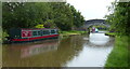
Narrowboat next to Faulkner's Bridge No 116
Image: © Mat Fascione
Taken: 6 Jul 2019
0.11 miles
2
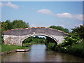
Faulkner's Bridge No.116, Shropshire Union Canal
Bridge name obtained from the CanalPlanAC website.
Image: © John Brightley
Taken: 15 Jun 2010
0.12 miles
3
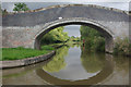
Faulkners Bridge, Shropshire Union Canal
Bridge no 116, looking towards Chester.
Image: © Stephen McKay
Taken: 9 Sep 2013
0.13 miles
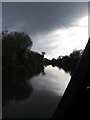
4
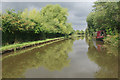
Shropshire Union Canal near Faulkners Bridge
Trees are reflected in the water but the clouds are threatening rain; note the narrowboat almost hiding on the non-towpath side.
Image: © Stephen McKay
Taken: 9 Sep 2013
0.13 miles
5
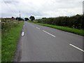
Long Lane at Milners Heath
Long Lane as it heads south wext towards Golden Nook.
Image: © Jeff Buck
Taken: 9 Jul 2012
0.14 miles
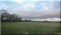
7
Shropshire Union Canal, near Milners Heath, Cheshire
Taken from our narrowboat travelling SE towards Beeston Castle
Image: © Paul Kleiman
Taken: 14 Nov 2009
0.23 miles
8
Looking northwest from Milners Heath Bridge.
Image: © Stephen Charles
Taken: 22 Jan 2006
0.24 miles