
IMAGES TAKEN NEAR TO
Church Steadings, CHESTER, CH3 7QX
Introduction
This page details the photographs taken nearby to Church Steadings, CH3 7QX by members of the Geograph project.
The Geograph project started in 2005 with the aim of publishing, organising and preserving representative images for every square kilometre of Great Britain, Ireland and the Isle of Man.

There are currently over 7.5m images from over14,400 individuals and you can help contribute to the project by visiting https://www.geograph.org.uk
Image Map
Images are licensed for reuse under creativecommons.org/licenses/by-sa/2.0
Notes
- Clicking on the map will re-center to the selected point.
- The higher the marker number, the further away the image location is from the centre of the postcode.
Image Listing (15 Images Found)
Images are licensed for reuse under creativecommons.org/licenses/by-sa/2.0
Image
Details
Distance
1
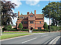
Church Farm, Waverton
"[John] Douglas at his most powerful". Brick and stone. Built 1882-83. Grade II listed.
Image: © Stephen Richards
Taken: 19 Aug 2014
0.02 miles
2
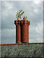
Detail of Institute, Waverton
Twisted stacks can be seen across this part of Cheshire, characteristic of John Douglas's work for the Eaton estate. Though most are not as fertile.
Wider view: Image
Image: © Stephen Richards
Taken: 19 Aug 2014
0.04 miles
5
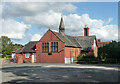
Institute, Waverton
By Douglas & Minshull, 1898-99. The attached cottage has typical Douglas/Eaton estate twisted stacks (Image]). Grade II listed.
Still called the Waverton Institute, it now appears to be more of a social club.
Image: © Stephen Richards
Taken: 19 Aug 2014
0.05 miles
6
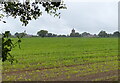
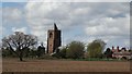
Farmland at Waverton
Viewed from the towpath of the Shropshire Union Canal, looking towards the Church of St Peter at Waverton.
Image: © Mat Fascione
Taken: 6 Jul 2019
0.05 miles
7
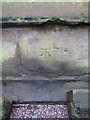
Bench mark on St Peter's church tower, Waverton
This Ordnance Survey bench mark is on the north face of the church tower. It is recorded on the 1899 O.S. map.
Image: © John S Turner
Taken: 23 Sep 2010
0.05 miles
8
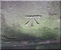
Ordnance Survey Cut Mark
This OS cut mark can be found on the NW face of St Peter's Church. It marks a point 38.861m above mean sea level.
Image: © Adrian Dust
Taken: 12 Jun 2016
0.05 miles
9
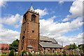
St Peter's Church, Waverton
The earliest documentary evidence of a place of worship on the site is in a charter of confirmation dated 1093. Later references are in a will dated 1599 and in documents relating to the building of a north chapel in 1640 by John Tilston of Lower Huxley Hall. In the 19th century, restorations of the body of the church took place, one in 1845 and another in 1888 by John Douglas when the clerestory was rebuilt. The pyramidal roof was added to the tower in the late 19th century.
An interesting feature of St Peter's is the large tower compared to the rest of the church.
Image: © Jeff Buck
Taken: 23 Jul 2012
0.05 miles
10
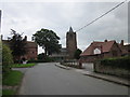
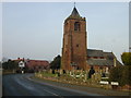
Village Road, Waverton
Village Road, Waverton with St Peter's Church in the centre.
Image: © Jeff Buck
Taken: 9 Jul 2012
0.05 miles