IMAGES TAKEN NEAR TO
Cotton Lane, CHESTER, CH3 7PY
Introduction
This page details the photographs taken nearby to Cotton Lane, CH3 7PY by members of the Geograph project.
The Geograph project started in 2005 with the aim of publishing, organising and preserving representative images for every square kilometre of Great Britain, Ireland and the Isle of Man.

There are currently over 7.5m images from over14,400 individuals and you can help contribute to the project by visiting https://www.geograph.org.uk
Image Map
Images are licensed for reuse under creativecommons.org/licenses/by-sa/2.0
Notes
- Clicking on the map will re-center to the selected point.
- The higher the marker number, the further away the image location is from the centre of the postcode.
Image Listing (7 Images Found)
Images are licensed for reuse under creativecommons.org/licenses/by-sa/2.0
Image
Details
Distance
1
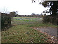
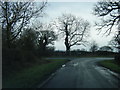
Entrance to Cotton Edmunds Farm
On an enforced section of road-walking as the useful and pleasant permissive path that passes behind the farm from Hockenhull Platts to near Stamford Mill is now closed.
Image: © Dave Dunford
Taken: 14 Apr 2016
0.02 miles
2
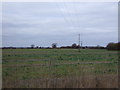
Cotton Edmunds Farm
Telephoto shot from the farm entrance. Hills around Kelsall in the background.
Image: © Dave Dunford
Taken: 14 Apr 2016
0.17 miles
3
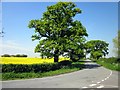
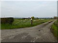
Cotton Edmunds, Cheshire
Taken at the junction of Plough Lane, Cotton Lane and Platts Lane.
Image: © Jeff Buck
Taken: 23 May 2012
0.18 miles
5
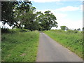
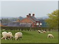
Platts Lane
The short section of road between the bridleway and Cotton Farm and Plough Lane. I think this may have been part of an old roman road towards Tarvin.
Image: © David Quinn
Taken: 3 Jul 2010
0.20 miles