IMAGES TAKEN NEAR TO
Churton Road, CHESTER, CH3 6QS
Introduction
This page details the photographs taken nearby to Churton Road, CH3 6QS by members of the Geograph project.
The Geograph project started in 2005 with the aim of publishing, organising and preserving representative images for every square kilometre of Great Britain, Ireland and the Isle of Man.

There are currently over 7.5m images from over14,400 individuals and you can help contribute to the project by visiting https://www.geograph.org.uk
Image Map
Images are licensed for reuse under creativecommons.org/licenses/by-sa/2.0
Notes
- Clicking on the map will re-center to the selected point.
- The higher the marker number, the further away the image location is from the centre of the postcode.
Image Listing (143 Images Found)
Images are licensed for reuse under creativecommons.org/licenses/by-sa/2.0
Image
Details
Distance
1

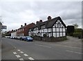
Churton Road
Property being renovated on Churton Road in Farndon.
Image: © Peter McDermott
Taken: 30 Apr 2022
0.01 miles
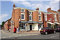
2
High Street cottages, Farndon
Three late 17th C timber-framed cottages on the High Street.
Image: © Eirian Evans
Taken: 6 Apr 2017
0.02 miles
4
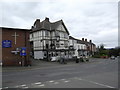
The Farndon
Originally built in the 16th Century and formerly known as The Raven, The Farndon sits in the heart of Farndon .
Image: © Eirian Evans
Taken: 6 Apr 2017
0.03 miles
5
Farndon Pharmacy, Farndon
Farndon Pharmacy on the corner of High Street and Churton Road in Farndon.
Image: © Jeff Buck
Taken: 6 Jul 2018
0.03 miles
6
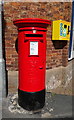
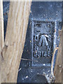
Elizabeth II postbox and defibrillator on High Street, Farndon
Outside the Post office.
Postbox No. CH3 158.
See Image] for context.
Image: © JThomas
Taken: 4 May 2019
0.03 miles
7
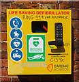
Defibrillator on Post Office, Farndon
See Image] for context.
Image: © JThomas
Taken: 4 May 2019
0.03 miles
8
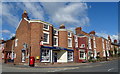
Post Office and pharmacy on High Street, Farndon
Image: © JThomas
Taken: 4 May 2019
0.03 miles
9
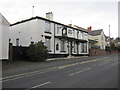
The Nag's Head, Farndon
Looking across High Street towards the Nag's Head, which has been closed for several years. On the left hand corner of the building, behind the large shrub, there is Ordnance Survey flush bracket G3148 - Image
Image: © John S Turner
Taken: 14 Aug 2011
0.04 miles
10
Flush Bracket G3148 on the Nag's Head, Farndon
The Nag's Head, Farndon has been closed for some time, and it may be obvious from the photo that now there is a large buddleia bush growing in front of the flush bracket. See also Image]
Image: © John S Turner
Taken: 14 Aug 2011
0.04 miles