IMAGES TAKEN NEAR TO
Sibbersfield Lane, CHESTER, CH3 6NX
Introduction
This page details the photographs taken nearby to Sibbersfield Lane, CH3 6NX by members of the Geograph project.
The Geograph project started in 2005 with the aim of publishing, organising and preserving representative images for every square kilometre of Great Britain, Ireland and the Isle of Man.

There are currently over 7.5m images from over14,400 individuals and you can help contribute to the project by visiting https://www.geograph.org.uk
Image Map
Images are licensed for reuse under creativecommons.org/licenses/by-sa/2.0
Notes
- Clicking on the map will re-center to the selected point.
- The higher the marker number, the further away the image location is from the centre of the postcode.
Image Listing (5 Images Found)
Images are licensed for reuse under creativecommons.org/licenses/by-sa/2.0
Image
Details
Distance
1
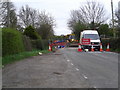
Sibbersfield Lane road closure
For a new sewer pipe connection.
Image: © Eirian Evans
Taken: 6 Apr 2017
0.09 miles
2
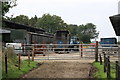
Sibbersfield Lane Farm
The footpath goes through the farm at this point.
Image: © Jeff Buck
Taken: 27 Jul 2011
0.18 miles
3
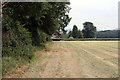
Footpath near Farndon
A public footpath to the north-east of Farndon here heading east towards the B5130.
Image: © Jeff Buck
Taken: 27 Jul 2011
0.19 miles
4
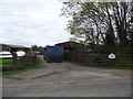
Entrance gate to Sibbersfield Lane Farm
Image: © Eirian Evans
Taken: 6 Apr 2017
0.19 miles
5
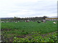
Cattle at Sibbersfield Lane Farm
A large herd of Friesian cattle.
Image: © Eirian Evans
Taken: 6 Apr 2017
0.23 miles