IMAGES TAKEN NEAR TO
Parker Drive, CHESTER, CH3 6NU
Introduction
This page details the photographs taken nearby to Parker Drive, CH3 6NU by members of the Geograph project.
The Geograph project started in 2005 with the aim of publishing, organising and preserving representative images for every square kilometre of Great Britain, Ireland and the Isle of Man.

There are currently over 7.5m images from over14,400 individuals and you can help contribute to the project by visiting https://www.geograph.org.uk
Image Map (Loading...)


Getting Data...Please wait
Leaflet Map data © OpenStreetMap
Images are licensed for reuse under creativecommons.org/licenses/by-sa/2.0
Notes
- Clicking on the map will re-center to the selected point.
- The higher the marker number, the further away the image location is from the centre of the postcode.
Image Listing (168 Images Found)
Images are licensed for reuse under creativecommons.org/licenses/by-sa/2.0
Image
Details
Distance
1
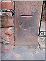
Bench mark alongside Barton Road, Farndon
This large bench mark is on the gatepost in front of Glen Haven on Barton Road, Farndon, although the O.S. claim it belongs to Holly Cottage next door. The mark was recorded on the 1874 O.S. map levelled at 78.6 feet. See also Image]
Image: © John S Turner
Taken: 14 Aug 2011
0.11 miles
2
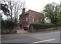
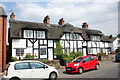
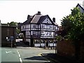
The Old Doctor's House, Barton Road
On the junction with Church Lane. Grade II* listed, now a private residence.
Image: © Eirian Evans
Taken: 6 Apr 2017
0.11 miles
3
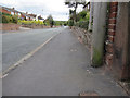
Barton Road, Farndon, and a bench mark
Looking along Barton Road from outside Glen Haven and Holly Cottage. There is a bench mark on the gatepost on the right - Image
Image: © John S Turner
Taken: 14 Aug 2011
0.11 miles
5
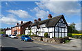
Black and White Cottages, High Street, Farndon
The Black and White Cottages in High Street, Farndon probably date from the late 17th century, they are Grade II listed.
Image: © Jeff Buck
Taken: 6 Jul 2018
0.14 miles
7
Main Road Farndon near Chester
Main Road Farndon near Chester.
The Main Road goes down hill towards the River Dee Bridge.
Image: © chestertouristcom
Taken: 7 Jul 2004
0.16 miles
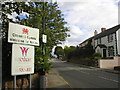
8
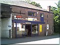
Shops on the B5130 on the way into Farndon
Farndon near Chester.
Image: © chestertouristcom
Taken: 7 Jul 2004
0.16 miles
9
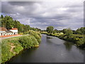
River Dee between Holt and Farndon
The river marks the boundary of England, on the left of the photograph, and Wales on the right.
Image: © Richard Slessor
Taken: 11 Jul 2004
0.16 miles
10
Welcome to Wales
Sign at the Welsh/English border at Holt.
Image: © Richard Slessor
Taken: 11 Jul 2004
0.16 miles