IMAGES TAKEN NEAR TO
Normandy Crescent, CHESTER, CH3 6FS
Introduction
This page details the photographs taken nearby to Normandy Crescent, CH3 6FS by members of the Geograph project.
The Geograph project started in 2005 with the aim of publishing, organising and preserving representative images for every square kilometre of Great Britain, Ireland and the Isle of Man.

There are currently over 7.5m images from over14,400 individuals and you can help contribute to the project by visiting https://www.geograph.org.uk
Image Map
Images are licensed for reuse under creativecommons.org/licenses/by-sa/2.0
Notes
- Clicking on the map will re-center to the selected point.
- The higher the marker number, the further away the image location is from the centre of the postcode.
Image Listing (3 Images Found)
Images are licensed for reuse under creativecommons.org/licenses/by-sa/2.0
Image
Details
Distance
1
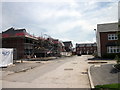
Green Howards Road, Huntington
New housing estate on the site of an old army camp at Huntington near Chester.
Image: © Jeff Buck
Taken: 26 May 2014
0.24 miles
2
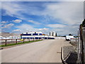
New Housing Estate, Huntington
New housing estate on the site of an old army camp at Huntington near Chester.
Image: © Jeff Buck
Taken: 26 May 2014
0.24 miles
3
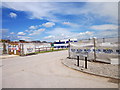
Green Howards Road, Huntington
New housing estate on the site of an old army camp at Huntington near Chester.
Image: © Jeff Buck
Taken: 26 May 2014
0.24 miles