IMAGES TAKEN NEAR TO
St. Giles, Sandy Lane, CHESTER, CH3 5UE
Introduction
This page details the photographs taken nearby to St. Giles, Sandy Lane, CH3 5UE by members of the Geograph project.
The Geograph project started in 2005 with the aim of publishing, organising and preserving representative images for every square kilometre of Great Britain, Ireland and the Isle of Man.

There are currently over 7.5m images from over14,400 individuals and you can help contribute to the project by visiting https://www.geograph.org.uk
Image Map
Images are licensed for reuse under creativecommons.org/licenses/by-sa/2.0
Notes
- Clicking on the map will re-center to the selected point.
- The higher the marker number, the further away the image location is from the centre of the postcode.
Image Listing (181 Images Found)
Images are licensed for reuse under creativecommons.org/licenses/by-sa/2.0
Image
Details
Distance
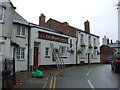
1
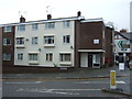
Flats on Sandy lane, Chester
Showing position of Postbox No. CH3 94.
See Image] for postbox.
Image: © JThomas
Taken: 12 Nov 2016
0.00 miles
2
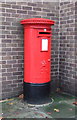
Elizabeth II postbox on Christleton Road, Chester
Postbox No. CH3 94.
See Image] for context.
Image: © JThomas
Taken: 12 Nov 2016
0.00 miles
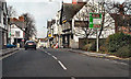
3
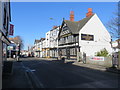
Christleton Road, Boughton
Looking along Christleton Road towards Chester with Ye Gardeners Arms on the right - Image
Image: © John S Turner
Taken: 18 Feb 2016
0.01 miles
4
Ye Gardeners Arms, Christleton Road, Boughton
Looking across Christleton Road towards Ye Gardeners Arms. There are two Cbester City boundary stones set into the front wall of the public house near the wooden gate - see Image
Image: © John S Turner
Taken: 18 Feb 2016
0.01 miles
5
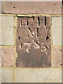
Chester City boundary stone on Ye Gardeners Arms
This boundary stone is set at head height into the south west face of Ye Gardeners Arms in Christleton Road. The inscription refers to: Henry Hegg who was Mayor of Chester in 1784–5. There is a separate weathered stone near pavement level, which appears to carry the same details, but was impossible to photograph on this day. See also Image
Milestone Society National ID: CH_CHES15pb
Image: © John S Turner
Taken: 18 Feb 2016
0.02 miles
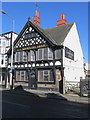
6
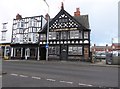
The Gardeners Arms, 57 Christleton Road
This public house, built in 1907 for the Albion Brewery is a Grade II listed building.
Image: © Eirian Evans
Taken: 24 Feb 2016
0.02 miles
7
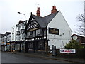
Ye Gardeners Arms
Public house on Christleton Road.
Image: © JThomas
Taken: 12 Nov 2016
0.02 miles
8
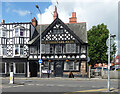
Ye Gardener's Arms, Christleton Road, Chester
Half-timbered pub by J.H. Davies & Sons, 1907. Grade II listed.
A stone at the right end is inscribed "H[?] H M 1785" - see Image] for more info.
Image: © Stephen Richards
Taken: 18 Aug 2014
0.02 miles