IMAGES TAKEN NEAR TO
Langport Drive, CHESTER, CH3 5LY
Introduction
This page details the photographs taken nearby to Langport Drive, CH3 5LY by members of the Geograph project.
The Geograph project started in 2005 with the aim of publishing, organising and preserving representative images for every square kilometre of Great Britain, Ireland and the Isle of Man.

There are currently over 7.5m images from over14,400 individuals and you can help contribute to the project by visiting https://www.geograph.org.uk
Image Map
Images are licensed for reuse under creativecommons.org/licenses/by-sa/2.0
Notes
- Clicking on the map will re-center to the selected point.
- The higher the marker number, the further away the image location is from the centre of the postcode.
Image Listing (18 Images Found)
Images are licensed for reuse under creativecommons.org/licenses/by-sa/2.0
Image
Details
Distance
1

Life's a Beech
The main trunk splits into three, to make an interesting shape when viewed from below. Located next to the Youth Centre, Vicar's Cross, Chester.
Image: © BrianPritchard
Taken: 8 Jan 2008
0.10 miles
2

Square One Youth Centre, Vicar's Cross
Located on Thackeray Drive, Vicar's Cross, Chester. Meet twice a week, Tuesday and Thursday night.
Image: © BrianPritchard
Taken: 8 Jan 2008
0.10 miles
3

Scout Hut, Vicar's Cross
The scout hut is located in the corner of the playing field, on Thackeray Drive, Vicar's Cross, Chester.
Image: © BrianPritchard
Taken: 8 Jan 2008
0.13 miles
4

The Centurion Pub, Vicars Cross, Chester
The Centurion is a modern (1960/70's) housing estate pub on Oldfield Drive, Vicars Cross, Chester.
Image: © Jeff Buck
Taken: 13 Mar 2013
0.15 miles
5

Football pitch, Thackeray Drive, Chester
There are two full size football pitches on this playfield, located in a residential area of Chester. The field is also popular with dog walkers, unfortunately, not all clean up the mess, no excuse as there are dog bins on site.
Image: © BrianPritchard
Taken: 8 Jan 2008
0.16 miles
6
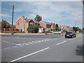
Green Lane Vicars Cross
Green Lane joins the A51 to the A41 through a residential area of east Chester.
Image: © Dennis Turner
Taken: 29 Aug 2005
0.17 miles
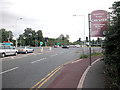
8
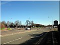
The A51 (Vicars Cross Road), Chester
The A51 (Vicars Cross Road) as it crosses the A41 ring road.
Image: © Jeff Buck
Taken: 6 Mar 2012
0.20 miles
9
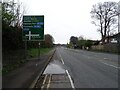
Beacon beside Hare Lane
Looking north west from the bridge over the A55.
Image: © JThomas
Taken: 3 Dec 2016
0.21 miles
10
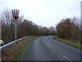
Vicars X
On the 1940s OS map the road ahead is marked as Watling Street. One of the Roman military roads.
Image: © Dennis Turner
Taken: 27 Aug 2005
0.21 miles