IMAGES TAKEN NEAR TO
Rosslyn Road, CHESTER, CH3 5HS
Introduction
This page details the photographs taken nearby to Rosslyn Road, CH3 5HS by members of the Geograph project.
The Geograph project started in 2005 with the aim of publishing, organising and preserving representative images for every square kilometre of Great Britain, Ireland and the Isle of Man.

There are currently over 7.5m images from over14,400 individuals and you can help contribute to the project by visiting https://www.geograph.org.uk
Image Map (Loading...)


Getting Data...Please wait
Leaflet Map data © OpenStreetMap
Images are licensed for reuse under creativecommons.org/licenses/by-sa/2.0
Notes
- Clicking on the map will re-center to the selected point.
- The higher the marker number, the further away the image location is from the centre of the postcode.
Image Listing (25 Images Found)
Images are licensed for reuse under creativecommons.org/licenses/by-sa/2.0
Image
Details
Distance
1
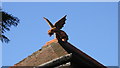
Dragon finial, old lodge house for Hoole Hall, Chester
The lodge house is now isolated from the Hall, due to the A41 cutting across the old driveway.
Image: © BrianPritchard
Taken: 12 Jan 2006
0.03 miles
2
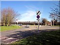
Green Lane, Vicars Cross
The junction of Green Lane and the A41 ring road.
Image: © Jeff Buck
Taken: 6 Mar 2012
0.07 miles
3
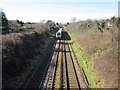
The Chester to Warrington Line
The railway as it heads towards Chester.
Image: © Jeff Buck
Taken: 6 Mar 2012
0.08 miles
4
Approaching Green Lane, Vicars Cross
The approach to Green Lane from the footpath/cycleway on the A41 ring road.
Image: © Jeff Buck
Taken: 6 Mar 2012
0.09 miles
5
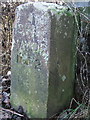
Boundary Stone
The inscription reads,
C N R
MAYOR
1972
Location next to footpath, alongside the A41
Image: © BrianPritchard
Taken: 23 Dec 2007
0.11 miles
6
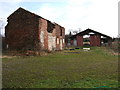
Disused House and outbuilding, Piper's Ash
This old building could have been a farmhouse, but now is a ruin. There has been a fire inside at some point and the roof is incomplete. Hidden under brambles at the nearest corner, on the outside, is a large cast iron pot, encased in brickwork, maybe for doing washing.
Image: © BrianPritchard
Taken: 7 Feb 2008
0.11 miles
7
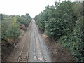
Hoole Railway
Looking towards Chester station this line connects North Wales with the West Coast main line at Warrington.
Image: © Dennis Turner
Taken: 27 Aug 2005
0.13 miles
9

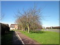
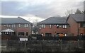
Football pitch, Thackeray Drive, Chester
There are two full size football pitches on this playfield, located in a residential area of Chester. The field is also popular with dog walkers, unfortunately, not all clean up the mess, no excuse as there are dog bins on site.
Image: © BrianPritchard
Taken: 8 Jan 2008
0.13 miles
10

Pipers Ash
Part of the parish of Guilden Sutton.
Image: © Dennis Turner
Taken: 29 Aug 2005
0.13 miles