IMAGES TAKEN NEAR TO
Maytree Avenue, CHESTER, CH3 5HQ
Introduction
This page details the photographs taken nearby to Maytree Avenue, CH3 5HQ by members of the Geograph project.
The Geograph project started in 2005 with the aim of publishing, organising and preserving representative images for every square kilometre of Great Britain, Ireland and the Isle of Man.

There are currently over 7.5m images from over14,400 individuals and you can help contribute to the project by visiting https://www.geograph.org.uk
Image Map
Images are licensed for reuse under creativecommons.org/licenses/by-sa/2.0
Notes
- Clicking on the map will re-center to the selected point.
- The higher the marker number, the further away the image location is from the centre of the postcode.
Image Listing (6 Images Found)
Images are licensed for reuse under creativecommons.org/licenses/by-sa/2.0
Image
Details
Distance
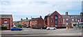
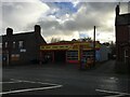
1
Green Lane shops
A view looking to the northeast across Green Lane towards the shops at the junction of Oldfield Drive. Vicars Cross United Reformed Church is on the right.
Image: © Phil Williams
Taken: 25 Dec 2006
0.05 miles
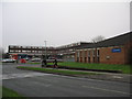
2
Shaftesbury Avenue, New Years Day 2006
A view looking northwest along Shaftesbury Avenue, Vicars Cross at midday Jan 1 2006.
Image: © Phil Williams
Taken: 1 Jan 2006
0.10 miles
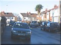
3

The Centurion Pub, Vicars Cross, Chester
The Centurion is a modern (1960/70's) housing estate pub on Oldfield Drive, Vicars Cross, Chester.
Image: © Jeff Buck
Taken: 13 Mar 2013
0.15 miles
4
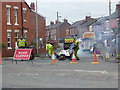
Men at work!
Resurfacing work being carried out at Pearl Lane.
Image: © Eirian Evans
Taken: 22 Mar 2016
0.18 miles
5
National Tyres, Vicars Cross Road, Chester
Image: © Steven Brown
Taken: 18 Nov 2022
0.19 miles