IMAGES TAKEN NEAR TO
Kinseys Lane, CHESTER, CH2 4NS
Introduction
This page details the photographs taken nearby to Kinseys Lane, CH2 4NS by members of the Geograph project.
The Geograph project started in 2005 with the aim of publishing, organising and preserving representative images for every square kilometre of Great Britain, Ireland and the Isle of Man.

There are currently over 7.5m images from over14,400 individuals and you can help contribute to the project by visiting https://www.geograph.org.uk
Image Map
Images are licensed for reuse under creativecommons.org/licenses/by-sa/2.0
Notes
- Clicking on the map will re-center to the selected point.
- The higher the marker number, the further away the image location is from the centre of the postcode.
Image Listing (14 Images Found)
Images are licensed for reuse under creativecommons.org/licenses/by-sa/2.0
Image
Details
Distance
3
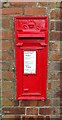
George V postbox on The Square, Ince
Postbox No. CH2 295.
See Image] for contrast.
Image: © JThomas
Taken: 2 Sep 2024
0.20 miles
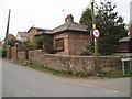
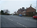
4
Houses on The Square, Ince
Showing position of Postbox No. CH2 295.
See Image] for postbox.
Image: © JThomas
Taken: 2 Sep 2024
0.20 miles
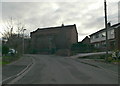
5
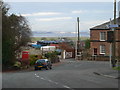
Ince
View down Pool Lane towards The Square. In the distance is the river Mersey, and beyond it is Liverpool Airport.
Image: © Eirian Evans
Taken: 22 Dec 2011
0.21 miles
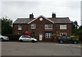
7
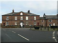
1-3 The Square, Ince
A late Georgian symmetrical 5-bay 2-storey terrace. It was built as a hotel for Mersey ferry passengers, and converted to a house flanked by 2 slightly recessed cottages. It is Grade II listed http://www.imagesofengland.org.uk/details/default.aspx?id=56314
Image: © Eirian Evans
Taken: 22 Dec 2011
0.22 miles
8
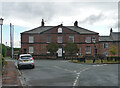
1-3 The Square, Ince
Attractive early C19th house built for Edmund Yates as a hotel for passengers on the ferry service which he was trying to develop. Grade II listed.
Image: © Stephen Richards
Taken: 22 Aug 2014
0.22 miles
9
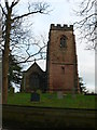
The church of St James the Great, Ince
Red sandstone church on the site of a Norman church. The tower and part of the chancel date from medieval times.
Image: © Eirian Evans
Taken: 22 Dec 2011
0.23 miles
10
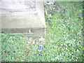
Cut Mark: St James Church, Ince
OS Cut Mark on St James Church, Ince. Number B11340 on the Benchmark Database, see http://www.bench-marks.org.uk/bm37719
Image: © VBForever
Taken: 24 Apr 2011
0.23 miles