IMAGES TAKEN NEAR TO
Poplar Hall Lane, CHESTER, CH2 4DE
Introduction
This page details the photographs taken nearby to Poplar Hall Lane, CH2 4DE by members of the Geograph project.
The Geograph project started in 2005 with the aim of publishing, organising and preserving representative images for every square kilometre of Great Britain, Ireland and the Isle of Man.

There are currently over 7.5m images from over14,400 individuals and you can help contribute to the project by visiting https://www.geograph.org.uk
Image Map
Images are licensed for reuse under creativecommons.org/licenses/by-sa/2.0
Notes
- Clicking on the map will re-center to the selected point.
- The higher the marker number, the further away the image location is from the centre of the postcode.
Image Listing (7 Images Found)
Images are licensed for reuse under creativecommons.org/licenses/by-sa/2.0
Image
Details
Distance
1
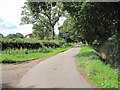
Minor Cul-de-Sac Road
A minor road linking Poplarhall with Backford, which ends shortly after the motorway bridge
Image: © David Quinn
Taken: 8 Aug 2009
0.02 miles
2
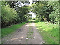
Bridleway and Private Drive
The start of the bridleway between the minor road and Rake Lane is on a private driveway for a large farm.
Image: © David Quinn
Taken: 8 Aug 2009
0.07 miles
3
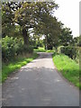
Minor Cul-de-Sac Road
A minor road linking Poplarhall with Backford, which ends shortly after the motorway bridge.
Image: © David Quinn
Taken: 8 Aug 2009
0.10 miles

5
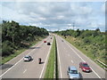
M56 Motorway
For a long time the motorway ended at a roundabout just beyond the horizon of this photo, but after hefty work throughout 2008 there is now a through dual-carriageway road right into Wales.
Image: © David Quinn
Taken: 8 Aug 2009
0.16 miles
6

M56 Motorway near Poplar Hall
The bridge in the background carries a minor road and - at higher scales - is in gridsquare SJ4072 over the motorway.
Image: © Peter Whatley
Taken: 18 Jan 2011
0.16 miles
7

Poplar Hall Lane
Poplar Hall Lane near Backford is a no through road leading to Mount Farm and Poplarhall.
Image: © Jeff Buck
Taken: 18 Jun 2012
0.24 miles