IMAGES TAKEN NEAR TO
Longburgh Close, CHESTER, CH2 3TA
Introduction
This page details the photographs taken nearby to Longburgh Close, CH2 3TA by members of the Geograph project.
The Geograph project started in 2005 with the aim of publishing, organising and preserving representative images for every square kilometre of Great Britain, Ireland and the Isle of Man.

There are currently over 7.5m images from over14,400 individuals and you can help contribute to the project by visiting https://www.geograph.org.uk
Image Map (Loading...)


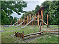
Getting Data...Please wait
Leaflet Map data © OpenStreetMap
Images are licensed for reuse under creativecommons.org/licenses/by-sa/2.0
Notes
- Clicking on the map will re-center to the selected point.
- The higher the marker number, the further away the image location is from the centre of the postcode.
Image Listing (100 Images Found)
Images are licensed for reuse under creativecommons.org/licenses/by-sa/2.0
Image
Details
Distance
1
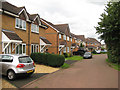
Melkridge Close 2, Hoole
The roads in this area appear to be named after places in Northumberland, see http://en.wikipedia.org/wiki/Melkridge
Image: © Peter Craine
Taken: 16 Aug 2008
0.06 miles
2
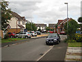
Melkridge Close 1 , Hoole
The roads in this area appear to be named after places in Northumberland, see http://en.wikipedia.org/wiki/Melkridge
Image: © Peter Craine
Taken: 16 Aug 2008
0.08 miles
3
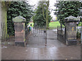
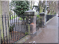
The south-west entrance to Alexandra Park, Hoole
This is the south-west entrance to Alexandra Park from Panton Road and the left-hand gatepost seems to have suffered some recent damage. There is a bench mark at the bottom of the left-hand post - Image
Image: © John S Turner
Taken: 30 Mar 2011
0.11 miles
4
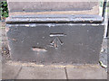
Bench mark in Panton Road
This bench mark is on a gatepost by the south-west entrance to Alexandra Park. See also Image
Image: © John S Turner
Taken: 30 Mar 2011
0.11 miles
5
Damaged gatepost at the south-west entrance to Alexandra Park
This is the south-west entrance to Alexandra Park from Panton Road and the gatepost has suffered some recent damage. There is a bench mark at the bottom of the damaged pillar - Image
Image: © John S Turner
Taken: 30 Mar 2011
0.11 miles
6
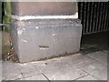
Benchmark on the gate into Alexandra Park, Hoole
The Benchmark is located at the base of the left hand gate-post at the entrance to Alexandra Park, Panton Road, Hoole, Chester
Image: © BrianPritchard
Taken: 23 Jan 2008
0.12 miles
7
Narrows Community Park, Hoole, Chester
Wikipedia http://en.wikipedia.org/wiki/Hoole
Image: © Jeff Buck
Taken: 24 Jan 2013
0.12 miles
8
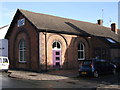
Hoole Baptist Church, Hoole, Chester
Dated 1883, the Hoole Baptist Church stands at the corner of Westminster Road and Ward's Terrace, Hoole, Chester. In total Hoole has, or has had, eight ecclesiastical buildings within its limits
Image: © BrianPritchard
Taken: 2 Feb 2008
0.13 miles
9
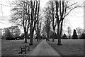
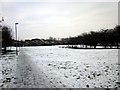
Alexandra Park, Chester
Alexandra Park in Hoole, Chester taken during the COVID-19 pandemic of 2020. At present most parks and playing fields are still open to the public.
Image: © Jeff Buck
Taken: 3 Apr 2020
0.14 miles