IMAGES TAKEN NEAR TO
Shavington Avenue, CHESTER, CH2 3RD
Introduction
This page details the photographs taken nearby to Shavington Avenue, CH2 3RD by members of the Geograph project.
The Geograph project started in 2005 with the aim of publishing, organising and preserving representative images for every square kilometre of Great Britain, Ireland and the Isle of Man.

There are currently over 7.5m images from over14,400 individuals and you can help contribute to the project by visiting https://www.geograph.org.uk
Image Map (Loading...)


Getting Data...Please wait
Leaflet Map data © OpenStreetMap
Images are licensed for reuse under creativecommons.org/licenses/by-sa/2.0
Notes
- Clicking on the map will re-center to the selected point.
- The higher the marker number, the further away the image location is from the centre of the postcode.
Image Listing (116 Images Found)
Images are licensed for reuse under creativecommons.org/licenses/by-sa/2.0
Image
Details
Distance
2
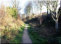
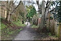
Newton Hollows
Newton Hollows is a medieval hollow way (or sunken lane) created over hundreds of years by the constant passage of people carts and animals. It originated as the Roman road between the legionary fortress of Chester and the important Roman manufacturing centre at Wilderspool (Warrington).
In the 12th century it was known as the 'Valley of the Demons'. It was thought to be haunted and travellers feared an encounter with the 'Hound of Hell', a 'huge slavering black dog with great white teeth like knives'.
The Hollows today is a 500 metre green corridor and public right of way and has a mix of large trees seasonal undergrowth.
Image: © Jeff Buck
Taken: 19 Jan 2012
0.06 miles
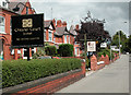
4
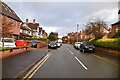
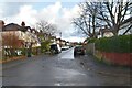
Hoole Road
This section of the road is lined by various guest houses and hotels.
Image: © Trevor Harris
Taken: 17 Jul 2011
0.08 miles
5
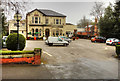
The Oaklands Hotel, Hoole Road, Chester
Image: © David Dixon
Taken: 15 Apr 2016
0.08 miles
7
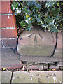
Rivet bench mark on Hoole Road
This rivet bench mark is on the stone wall in front of #91 Hoole Road, The Cedars (also Hoole Library), at the boundary with #93 The Oaklands Hotel. The mark is indicated on the 1873 O.S. map, levelled at 89.3 feet. See also Image
Image: © John S Turner
Taken: 25 Mar 2011
0.08 miles
8
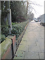
Hoole Road in front of #91, Hoole Library
Looking along the pavement in front of #91 Hoole Road, Hoole Library. There is a rivet bench mark on the first low sandstone block beyond the red-brick wall. Image
Image: © John S Turner
Taken: 25 Mar 2011
0.08 miles
9
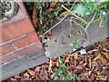
Ordnance Survey Rivet
This OS rivet can be found on the wall between Nos 93 & 91 Hoole Road. It marks a point 27.271m above mean sea level.
Image: © Adrian Dust
Taken: 13 Sep 2022
0.08 miles
10
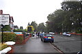
Hotel Road
Hoole Road Chester leads from the M53/A55 road junction into Chester and provides a wide range of choice of hotel and B&B accommodation.
Image: © Dennis Turner
Taken: 14 Aug 2005
0.09 miles