IMAGES TAKEN NEAR TO
Hoole Road, CHESTER, CH2 3PB
Introduction
This page details the photographs taken nearby to Hoole Road, CH2 3PB by members of the Geograph project.
The Geograph project started in 2005 with the aim of publishing, organising and preserving representative images for every square kilometre of Great Britain, Ireland and the Isle of Man.

There are currently over 7.5m images from over14,400 individuals and you can help contribute to the project by visiting https://www.geograph.org.uk
Image Map
Images are licensed for reuse under creativecommons.org/licenses/by-sa/2.0
Notes
- Clicking on the map will re-center to the selected point.
- The higher the marker number, the further away the image location is from the centre of the postcode.
Image Listing (66 Images Found)
Images are licensed for reuse under creativecommons.org/licenses/by-sa/2.0
Image
Details
Distance
2
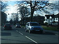
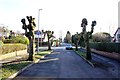
Hoole Road, Hoole, Chester
Hoole Road links the A41 and motorway network into the centre of Chester City
Image: © BrianPritchard
Taken: 11 Feb 2008
0.04 miles
4
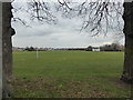
Coronation Recreation Ground, Hoole
Large field south of Hoole Road, laid out to 3 football fields and a bowling green.
Image: © Eirian Evans
Taken: 22 Mar 2016
0.06 miles
5
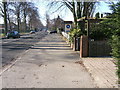
Fairfield Road, Chester
Looking towards Hoole Road.
Image: © Jeff Buck
Taken: 19 Jan 2012
0.07 miles
6
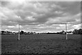
Coronation Playing Field, Chester - Play Postponed
An almost empty Coronation Playing Field in Hoole, Chester taken on my daily exercise walk during the COVID-19 pandemic of 2020. The football pitch is normally used by Dee Rangers FC. At present parks and playing fields in Chester are still open to the public.
Image: © Jeff Buck
Taken: 3 Apr 2020
0.07 miles
7
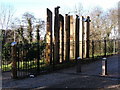
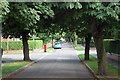
Gateway for Newton Hollows
The Hollows is an old Roman Road that went from Chester, north-east to Frodsham.
Image: © BrianPritchard
Taken: 23 Dec 2007
0.09 miles
8
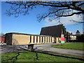
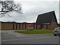
Hoole United Reformed Church, Chester
Hoole United Reformed Church on Hoole Road, Chester.
Hoole United Reformed Church http://www.hooleurc.org.uk/
Image: © Jeff Buck
Taken: 12 Mar 2013
0.10 miles
9
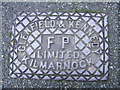
Cast Iron Grid Cover, Canadian Avenue, Hoole, Chester
Chester had its own iron foundries, so this cover has come a long way from home. Glenfield & Kennedy Limited Kilmarnock are still trading. Kennedy Patent Water Meter Co. Ltd. was formed in 1863, later they started another Co. of Glenfield Co. Ltd. in 1865. The two companies were merged in 1899, to form Glenfield & Kennedy Limited, which became the largest company of its type in the commonwealth.
Image: © BrianPritchard
Taken: 23 Jan 2008
0.10 miles