IMAGES TAKEN NEAR TO
Leahurst Close, CHESTER, CH2 3NS
Introduction
This page details the photographs taken nearby to Leahurst Close, CH2 3NS by members of the Geograph project.
The Geograph project started in 2005 with the aim of publishing, organising and preserving representative images for every square kilometre of Great Britain, Ireland and the Isle of Man.

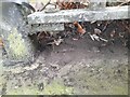
There are currently over 7.5m images from over14,400 individuals and you can help contribute to the project by visiting https://www.geograph.org.uk
Image Map (Loading...)


Getting Data...Please wait
Leaflet Map data © OpenStreetMap
Images are licensed for reuse under creativecommons.org/licenses/by-sa/2.0
Notes
- Clicking on the map will re-center to the selected point.
- The higher the marker number, the further away the image location is from the centre of the postcode.
Image Listing (102 Images Found)
Images are licensed for reuse under creativecommons.org/licenses/by-sa/2.0
Image
Details
Distance
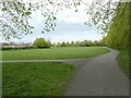
1
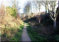
Newton Hollows
Newton Hollows is a medieval hollow way (or sunken lane) created over hundreds of years by the constant passage of people carts and animals. It originated as the Roman road between the legionary fortress of Chester and the important Roman manufacturing centre at Wilderspool (Warrington).
In the 12th century it was known as the 'Valley of the Demons'. It was thought to be haunted and travellers feared an encounter with the 'Hound of Hell', a 'huge slavering black dog with great white teeth like knives'.
The Hollows today is a 500 metre green corridor and public right of way and has a mix of large trees seasonal undergrowth.
Image: © Jeff Buck
Taken: 19 Jan 2012
0.05 miles
2
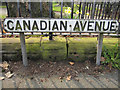
'Canadian Avenue' street sign and a bench mark
This street sign is at the north-west end of Canadian Avenue next to the entrance to Alexandra Park Image There is a rivet bench mark below the second 'AN' of 'CANADIAN', and directly underneath the railings. Image
Image: © John S Turner
Taken: 27 Mar 2011
0.08 miles
3
Rivet bench mark in Canadian Avenue
This rivet bench mark is on the low stone wall surrounding Alexandra Park, and directly behind the 'Canadian Avenue' street sign Image It would be impossible for the Ordnance Survey to use this mark as it is directly below the railings, so it must date to the period after WWII when the old railings were removed for salvage, and before the new railings were fitted.
Image: © John S Turner
Taken: 27 Mar 2011
0.08 miles
4
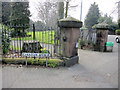
North-east entrance to Alexandra Park, Hoole
The north-east entrance to Alexandra Park at the junction of Canadian Avenue and Hoole Road. There is a rivet bench mark on the low wall behind the street sign Image
Image: © John S Turner
Taken: 27 Mar 2011
0.08 miles
5
Ordnance Survey Rivet
This OS rivet can be found on the wall SW side of Canadian Avenue. It marks a point 28.679m above mean sea level.
Image: © Adrian Dust
Taken: 13 Sep 2022
0.08 miles
6
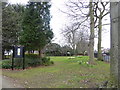
Alexandra Park, Hoole
The park has a bowling green and tennis courts but here near Hoole Road is a small memorial area where trees have been planted and memorial stones places beside them.
Image: © Eirian Evans
Taken: 22 Mar 2016
0.08 miles
7
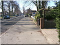
Hoole Road, Hoole, Chester
Hoole Road links the A41 and motorway network into the centre of Chester City
Image: © BrianPritchard
Taken: 11 Feb 2008
0.09 miles
8
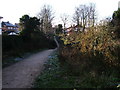
The Hollows
The view looking West-southwest, towards Newton Lane
Image: © BrianPritchard
Taken: 23 Dec 2007
0.09 miles
10
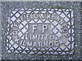
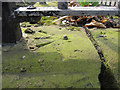
Cast Iron Grid Cover, Canadian Avenue, Hoole, Chester
Chester had its own iron foundries, so this cover has come a long way from home. Glenfield & Kennedy Limited Kilmarnock are still trading. Kennedy Patent Water Meter Co. Ltd. was formed in 1863, later they started another Co. of Glenfield Co. Ltd. in 1865. The two companies were merged in 1899, to form Glenfield & Kennedy Limited, which became the largest company of its type in the commonwealth.
Image: © BrianPritchard
Taken: 23 Jan 2008
0.11 miles