IMAGES TAKEN NEAR TO
Clare Avenue, CHESTER, CH2 3HS
Introduction
This page details the photographs taken nearby to Clare Avenue, CH2 3HS by members of the Geograph project.
The Geograph project started in 2005 with the aim of publishing, organising and preserving representative images for every square kilometre of Great Britain, Ireland and the Isle of Man.

There are currently over 7.5m images from over14,400 individuals and you can help contribute to the project by visiting https://www.geograph.org.uk
Image Map
Images are licensed for reuse under creativecommons.org/licenses/by-sa/2.0
Notes
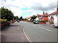
- Clicking on the map will re-center to the selected point.
- The higher the marker number, the further away the image location is from the centre of the postcode.
Image Listing (96 Images Found)
Images are licensed for reuse under creativecommons.org/licenses/by-sa/2.0
Image
Details
Distance
1
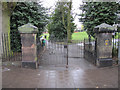
The south-west entrance to Alexandra Park, Hoole
This is the south-west entrance to Alexandra Park from Panton Road and the left-hand gatepost seems to have suffered some recent damage. There is a bench mark at the bottom of the left-hand post - Image
Image: © John S Turner
Taken: 30 Mar 2011
0.06 miles
2
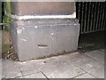
Damaged gatepost at the south-west entrance to Alexandra Park
This is the south-west entrance to Alexandra Park from Panton Road and the gatepost has suffered some recent damage. There is a bench mark at the bottom of the damaged pillar - Image
Image: © John S Turner
Taken: 30 Mar 2011
0.06 miles
3
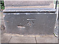
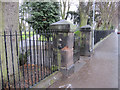
Bench mark in Panton Road
This bench mark is on a gatepost by the south-west entrance to Alexandra Park. See also Image
Image: © John S Turner
Taken: 30 Mar 2011
0.06 miles
4
Benchmark on the gate into Alexandra Park, Hoole
The Benchmark is located at the base of the left hand gate-post at the entrance to Alexandra Park, Panton Road, Hoole, Chester
Image: © BrianPritchard
Taken: 23 Jan 2008
0.06 miles
5
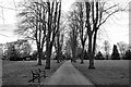
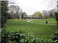
Alexandra Park, Chester
Alexandra Park in Hoole, Chester taken during the COVID-19 pandemic of 2020. At present most parks and playing fields are still open to the public.
Image: © Jeff Buck
Taken: 3 Apr 2020
0.09 miles
7
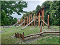
Playground in Alexandra Park, Hoole
Looking towards the children's playground in Alexandra Park from Panton Road. On this wet school-day the only sign of life was the pigeons.
Image: © John S Turner
Taken: 30 Mar 2011
0.10 miles
8
Melkridge Close 2, Hoole
The roads in this area appear to be named after places in Northumberland, see http://en.wikipedia.org/wiki/Melkridge
Image: © Peter Craine
Taken: 16 Aug 2008
0.11 miles
9
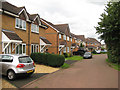
Canadian Avenue
Broad avenue in Hoole.
Image: © Dennis Turner
Taken: 14 Aug 2005
0.12 miles
10
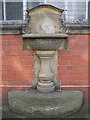
Drinking Fountain, Alexandra Park, Hoole
This drinking fountain is located behind the bowling pavilion, inside the park.
The inscription reads, Presented to Hoole Urban District by Wm.
Williams Esq. Sept. 24 1913 Chairman 1903 to 1906.
Alexandra Park was previously called Hoole Park and was officially opened on 7 May 1904 by Mr. R A Yerburgh, the local MP, with a silver key presented to him by William Williams.
Image: © BrianPritchard
Taken: 10 Feb 2008
0.12 miles