IMAGES TAKEN NEAR TO
Myrica Grove, CHESTER, CH2 3EW
Introduction
This page details the photographs taken nearby to Myrica Grove, CH2 3EW by members of the Geograph project.
The Geograph project started in 2005 with the aim of publishing, organising and preserving representative images for every square kilometre of Great Britain, Ireland and the Isle of Man.

There are currently over 7.5m images from over14,400 individuals and you can help contribute to the project by visiting https://www.geograph.org.uk
Image Map (Loading...)


Getting Data...Please wait
Leaflet Map data © OpenStreetMap
Images are licensed for reuse under creativecommons.org/licenses/by-sa/2.0
Notes
- Clicking on the map will re-center to the selected point.
- The higher the marker number, the further away the image location is from the centre of the postcode.
Image Listing (22 Images Found)
Images are licensed for reuse under creativecommons.org/licenses/by-sa/2.0
Image
Details
Distance

3
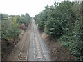
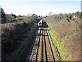
Hoole Railway
Looking towards Chester station this line connects North Wales with the West Coast main line at Warrington.
Image: © Dennis Turner
Taken: 27 Aug 2005
0.05 miles
5
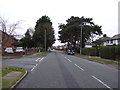
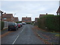
Hoole Lane looking south west
At the junction with Hoole Gardens.
Image: © JThomas
Taken: 3 Dec 2016
0.12 miles
6
The Chester to Warrington Line
The railway as it heads towards Chester.
Image: © Jeff Buck
Taken: 6 Mar 2012
0.12 miles
7
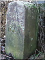
Boundary Stone
The inscription reads,
C N R
MAYOR
1972
Location next to footpath, alongside the A41
Image: © BrianPritchard
Taken: 23 Dec 2007
0.14 miles
9
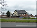
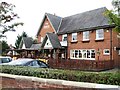
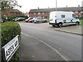
The Piper
Large pub near the junction of Hoole Lane and the A41 Chester Bypass.
Image: © Eirian Evans
Taken: 22 Mar 2016
0.15 miles