IMAGES TAKEN NEAR TO
Aldford Road, CHESTER, CH2 1SU
Introduction
This page details the photographs taken nearby to Aldford Road, CH2 1SU by members of the Geograph project.
The Geograph project started in 2005 with the aim of publishing, organising and preserving representative images for every square kilometre of Great Britain, Ireland and the Isle of Man.

There are currently over 7.5m images from over14,400 individuals and you can help contribute to the project by visiting https://www.geograph.org.uk
Image Map
Images are licensed for reuse under creativecommons.org/licenses/by-sa/2.0
Notes
- Clicking on the map will re-center to the selected point.
- The higher the marker number, the further away the image location is from the centre of the postcode.
Image Listing (9 Images Found)
Images are licensed for reuse under creativecommons.org/licenses/by-sa/2.0
Image
Details
Distance

3
Westlea School Upton
A junior school serving the local area
Image: © Dennis Turner
Taken: 14 Aug 2005
0.13 miles
4
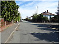
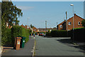
Weston Grove, Upton
Junction with St James Avenue.
Image: © JThomas
Taken: 14 Sep 2019
0.16 miles
5

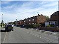
Ubiquitous wheelie bins at Upton
Have these bins overtaken the road cone as plastic enemy No 1?
Image: © Row17
Taken: 11 Aug 2009
0.17 miles
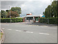
6
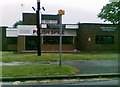
The Gamekeeper soon to be Plush Spice
Public house to Indian Restaurant
Image: © Alex McGregor
Taken: 15 Jun 2011
0.18 miles
8

Shops on Weston Grove, Upton
Showing position of Postbox No. CH2 289.
See Image] for postbox.
Image: © JThomas
Taken: 14 Sep 2019
0.22 miles
9
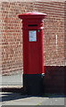
Victorian postbox on Weston Grove, Upton
Postbox No. CH2 289.
See Image] for context.
Image: © JThomas
Taken: 14 Sep 2019
0.23 miles