IMAGES TAKEN NEAR TO
Iver Road, CHESTER, CH2 1RL
Introduction
This page details the photographs taken nearby to Iver Road, CH2 1RL by members of the Geograph project.
The Geograph project started in 2005 with the aim of publishing, organising and preserving representative images for every square kilometre of Great Britain, Ireland and the Isle of Man.

There are currently over 7.5m images from over14,400 individuals and you can help contribute to the project by visiting https://www.geograph.org.uk
Image Map
Images are licensed for reuse under creativecommons.org/licenses/by-sa/2.0
Notes
- Clicking on the map will re-center to the selected point.
- The higher the marker number, the further away the image location is from the centre of the postcode.
Image Listing (21 Images Found)
Images are licensed for reuse under creativecommons.org/licenses/by-sa/2.0
Image
Details
Distance
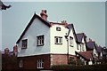
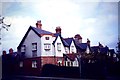
1
Heath Road
To the rear of houses in Heath Road.
Image: © Dennis Turner
Taken: 30 Mar 2008
0.04 miles

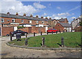
3
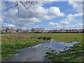
Chemistry Fields
Small recreation area under the control of Upton Parish Council. Interesting history of the site http://www.historyofuptonbychester.org.uk/chempitssandpit.html
Image: © Dennis Turner
Taken: 30 Mar 2008
0.07 miles
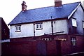
4
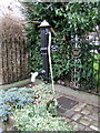
The Old Water Pump, Upton, Chester
The Old Water Pump on Heath Road, Upton, Chester. Follow this link http://www.historyofuptonbychester.org.uk/villagepump.html
Image: © BrianPritchard
Taken: 25 Jan 2008
0.09 miles