IMAGES TAKEN NEAR TO
Acorn Court, CHESTER, CH2 1JT
Introduction
This page details the photographs taken nearby to Acorn Court, CH2 1JT by members of the Geograph project.
The Geograph project started in 2005 with the aim of publishing, organising and preserving representative images for every square kilometre of Great Britain, Ireland and the Isle of Man.

There are currently over 7.5m images from over14,400 individuals and you can help contribute to the project by visiting https://www.geograph.org.uk
Image Map
Images are licensed for reuse under creativecommons.org/licenses/by-sa/2.0
Notes
- Clicking on the map will re-center to the selected point.
- The higher the marker number, the further away the image location is from the centre of the postcode.
Image Listing (19 Images Found)
Images are licensed for reuse under creativecommons.org/licenses/by-sa/2.0
Image
Details
Distance
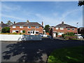
1
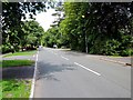
Caughall Road, Chester
Caughall Road heading north at Upton Heath.
Image: © Jeff Buck
Taken: 18 Jun 2012
0.05 miles
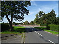
2
Long Lane
The A41 trunk road at Upton Heath.
Image: © Dennis Turner
Taken: 30 Mar 2008
0.17 miles
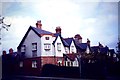
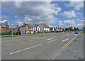
3

The Wheatsheaf Inn, Upton
The Wheatsheaf Inn is part of the Sizzling Pubs chain.
Image: © Jeff Buck
Taken: 6 Jun 2013
0.17 miles
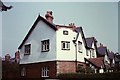
5
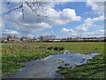
Chemistry Fields
Small recreation area under the control of Upton Parish Council. Interesting history of the site http://www.historyofuptonbychester.org.uk/chempitssandpit.html
Image: © Dennis Turner
Taken: 30 Mar 2008
0.20 miles
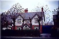
6

Flag Lane South, Upton-by-Chester
The road gets its "South" name because Flag Lane was cut in two by the A41
Image: © David Smith
Taken: 24 Apr 2024
0.20 miles