IMAGES TAKEN NEAR TO
Dale Drive, CHESTER, CH2 1EH
Introduction
This page details the photographs taken nearby to Dale Drive, CH2 1EH by members of the Geograph project.
The Geograph project started in 2005 with the aim of publishing, organising and preserving representative images for every square kilometre of Great Britain, Ireland and the Isle of Man.

There are currently over 7.5m images from over14,400 individuals and you can help contribute to the project by visiting https://www.geograph.org.uk
Image Map
Images are licensed for reuse under creativecommons.org/licenses/by-sa/2.0
Notes
- Clicking on the map will re-center to the selected point.
- The higher the marker number, the further away the image location is from the centre of the postcode.
Image Listing (8 Images Found)
Images are licensed for reuse under creativecommons.org/licenses/by-sa/2.0
Image
Details
Distance
1
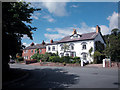
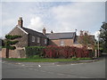
Old Houses in Upton by Chester
The white house in the picture is thought to date from 1745.
Image: © Dennis Turner
Taken: 5 Aug 2005
0.07 miles
2
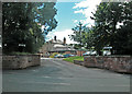
Upton Golf Club
Clubhouse in Upton Lane of Upton by Chester Golf Club.
Image: © Dennis Turner
Taken: 5 Aug 2005
0.09 miles
3
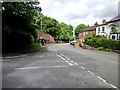
Upton Lane, Chester
At the junction of Church Lane (on the left) and Upton Lane.
Image: © Jeff Buck
Taken: 23 Jun 2012
0.10 miles
4
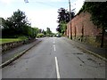
Church lane, Chester
Church Lane taken from the junction with Upton Lane.
Image: © Jeff Buck
Taken: 23 Jun 2012
0.12 miles
5
Upton Farm
The original building is thought to have started life as a smallholding in the 1700's which was extended over the years, first to an L shaped building and further extended to a quadrangle in the mid 1800's.
Image: © Sue Adair
Taken: 17 Oct 2014
0.13 miles
6
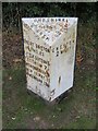
Old Milepost by the A5116, Liverpool Road, Upton by Chester
Cast iron post by the A5116, in parish of Upton by Chester (Chester District), roadside, on the verge, on West side of road. Cast iron CCC1896, erected by the County Council in the 19th century.
Inscription reads:-
: GREAT SUTTON / 4½ MILES / LITTLE SUTTON 5 / EASTHAM 7½ / BROMBOROUGH 9 / NEW FERRY 11 / BIRKENHEAD 13½ : : CHESHIRE / 1896 / COUNTY COUNCIL : : CHESTER / 2 MILES :
Maker:-
: W H SMITH & CO / MAKERS / WHITCHURCH :
Milestone Society National ID: CH_CHBH02
Image: © John S Turner
Taken: 1 Sep 2016
0.23 miles
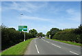
8
A41 approaching roundabout for Zoo entrance
Image: © John Firth
Taken: 9 Oct 2017
0.24 miles