IMAGES TAKEN NEAR TO
Demage Lane, Lea-by-Backford, CHESTER, CH1 6LP
Introduction
This page details the photographs taken nearby to Demage Lane, Lea-by-Backford, CH1 6LP by members of the Geograph project.
The Geograph project started in 2005 with the aim of publishing, organising and preserving representative images for every square kilometre of Great Britain, Ireland and the Isle of Man.

There are currently over 7.5m images from over14,400 individuals and you can help contribute to the project by visiting https://www.geograph.org.uk
Image Map
Images are licensed for reuse under creativecommons.org/licenses/by-sa/2.0
Notes
- Clicking on the map will re-center to the selected point.
- The higher the marker number, the further away the image location is from the centre of the postcode.
Image Listing (4 Images Found)
Images are licensed for reuse under creativecommons.org/licenses/by-sa/2.0
Image
Details
Distance
2
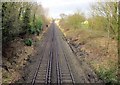
The Chester to Birkenhead Railway Line heading North
The Chester to Birkenhead Railway from Demage Lane railway bridge.
Wikipedia http://en.wikipedia.org/wiki/Chester_and_Birkenhead_Railway
Image: © Jeff Buck
Taken: 30 Jan 2013
0.17 miles
3
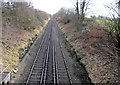
The Chester to Birkenhead Railway Line heading South
The Chester to Birkenhead Railway from Demage Lane railway bridge.
Wikipedia http://en.wikipedia.org/wiki/Chester_and_Birkenhead_Railway
Image: © Jeff Buck
Taken: 30 Jan 2013
0.21 miles
4
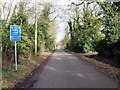
Demage Lane, Mollington
Wikipedia http://en.wikipedia.org/wiki/Mollington,_Cheshire
Image: © Jeff Buck
Taken: 30 Jan 2013
0.24 miles