IMAGES TAKEN NEAR TO
Hall Lane, CHESTER, CH1 6JB
Introduction
This page details the photographs taken nearby to Hall Lane, CH1 6JB by members of the Geograph project.
The Geograph project started in 2005 with the aim of publishing, organising and preserving representative images for every square kilometre of Great Britain, Ireland and the Isle of Man.

There are currently over 7.5m images from over14,400 individuals and you can help contribute to the project by visiting https://www.geograph.org.uk
Image Map
Images are licensed for reuse under creativecommons.org/licenses/by-sa/2.0
Notes
- Clicking on the map will re-center to the selected point.
- The higher the marker number, the further away the image location is from the centre of the postcode.
Image Listing (27 Images Found)
Images are licensed for reuse under creativecommons.org/licenses/by-sa/2.0
Image
Details
Distance
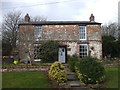
1
Shotwick Hall
Built in 1662 it is adjacent to Shotwick Hall Farm.
Image: © Dennis Turner
Taken: 4 Apr 2006
0.05 miles
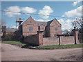
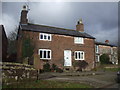
2

Shotwick Hall Farm, Shotwick
This house was built in 1662 and stands on the site of an earlier building. It is Grade II listed.
Image: © Colin Park
Taken: 3 Feb 2022
0.06 miles
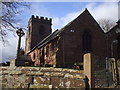
4
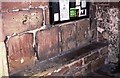
Porch of St Michael's Church, Shotwick
The grooves in the wall are said to have been created by the sharpening of arrow heads made by the archers of visiting armies passing through the village.
Image: © Jeff Buck
Taken: Unknown
0.08 miles
5
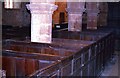
Interior of St Michael's Church, Shotwick
The box pews and octagonal pillars.
Image: © Jeff Buck
Taken: Unknown
0.08 miles
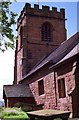
6
St Michael's Church, Shotwick
Another view of Shotwick church.
Image: © Jeff Buck
Taken: Unknown
0.08 miles
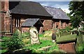
9
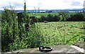
Iron Mooring Ring at Shotwick Churchyard
Once an important port on the Dee estuary, boats and ships were able to moor on the edge of the churchyard in Shotwick as this iron mooring ring proves. Now silted up, the land once part of the estuary became fields and more recently industrial estates have been built. In this photo, beyond the fields can be seen industrial units and in the far distance the Welsh hills.
Image: © Jeff Buck
Taken: Unknown
0.11 miles