IMAGES TAKEN NEAR TO
Deeside Lane, CHESTER, CH1 6BB
Introduction
This page details the photographs taken nearby to Deeside Lane, CH1 6BB by members of the Geograph project.
The Geograph project started in 2005 with the aim of publishing, organising and preserving representative images for every square kilometre of Great Britain, Ireland and the Isle of Man.

There are currently over 7.5m images from over14,400 individuals and you can help contribute to the project by visiting https://www.geograph.org.uk
Image Map
Images are licensed for reuse under creativecommons.org/licenses/by-sa/2.0
Notes
- Clicking on the map will re-center to the selected point.
- The higher the marker number, the further away the image location is from the centre of the postcode.
Image Listing (5 Images Found)
Images are licensed for reuse under creativecommons.org/licenses/by-sa/2.0
Image
Details
Distance
1
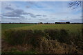
Looking towards Old Farm Cottages
Taken from the Wales Coast Path.
Image: © Ian S
Taken: 30 Jan 2022
0.05 miles
2
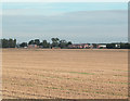
Sealand Nursery
Originally Bees Seeds "that grow" it is now owned by the horticultural seedsmen Webbs.
Image: © Dennis Turner
Taken: 30 Aug 2005
0.11 miles
3
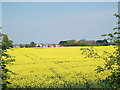
Winter rape in flower
The track through this crop can just be seen, the houses and buildings of the seed merchants at Sealand Nursery are in the distance. Image]
Image: © John Haynes
Taken: 2 May 2012
0.22 miles
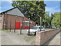
5
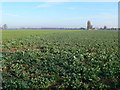
Winter greens, Sealand
Sealand is an area formed by silting at the head of the estuary of the River Dee and is farmed for crops.
Image: © Eirian Evans
Taken: 1 Mar 2012
0.23 miles