IMAGES TAKEN NEAR TO
Hermitage Road, CHESTER, CH1 6AF
Introduction
This page details the photographs taken nearby to Hermitage Road, CH1 6AF by members of the Geograph project.
The Geograph project started in 2005 with the aim of publishing, organising and preserving representative images for every square kilometre of Great Britain, Ireland and the Isle of Man.

There are currently over 7.5m images from over14,400 individuals and you can help contribute to the project by visiting https://www.geograph.org.uk
Image Map
Images are licensed for reuse under creativecommons.org/licenses/by-sa/2.0
Notes
- Clicking on the map will re-center to the selected point.
- The higher the marker number, the further away the image location is from the centre of the postcode.
Image Listing (8 Images Found)
Images are licensed for reuse under creativecommons.org/licenses/by-sa/2.0
Image
Details
Distance
2
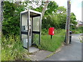
Elizabeth II postbox and telephone box on Hermitage Road, Saughall
Postbox No. CH1 4.
See Image] for close up.
Image: © JThomas
Taken: 15 Jun 2019
0.07 miles
3
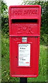
Close up, Elizabeth II postbox on Hermitage Road, Saughall
Postbox No. CH1 4.
See Image] for wider view.
Image: © JThomas
Taken: 15 Jun 2019
0.07 miles
4
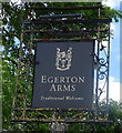
Sign for the Egerton Arms, Saughall
See Image] for context.
Image: © JThomas
Taken: 15 Jun 2019
0.08 miles
5
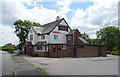
The Egerton Arms, Saughall
On Hermitage Road.
Image: © JThomas
Taken: 15 Jun 2019
0.10 miles
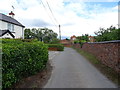
6
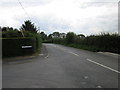
Hermitage Road, Saughall
Hermitage Road at the junction of Aspen Grove.
Image: © Jeff Buck
Taken: 24 Aug 2012
0.11 miles
7
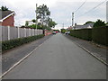
Aspen Grove, Saughall
Aspen Grove is a no through road off Hermitage Road near Saughall.
Image: © Jeff Buck
Taken: 24 Aug 2012
0.12 miles
8
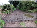
Green Lane near Blacon
It was impossible to investigate the grid square any further from this end as this patch of mud separating Poplars Farm (on the right) and the field, looked several inches deep. Green Lane connects further ahead with Kingswood Lane.
Image: © Jeff Buck
Taken: 24 Aug 2012
0.14 miles