IMAGES TAKEN NEAR TO
Highfield Road, CHESTER, CH1 5AX
Introduction
This page details the photographs taken nearby to Highfield Road, CH1 5AX by members of the Geograph project.
The Geograph project started in 2005 with the aim of publishing, organising and preserving representative images for every square kilometre of Great Britain, Ireland and the Isle of Man.

There are currently over 7.5m images from over14,400 individuals and you can help contribute to the project by visiting https://www.geograph.org.uk
Image Map
Images are licensed for reuse under creativecommons.org/licenses/by-sa/2.0
Notes
- Clicking on the map will re-center to the selected point.
- The higher the marker number, the further away the image location is from the centre of the postcode.
Image Listing (17 Images Found)
Images are licensed for reuse under creativecommons.org/licenses/by-sa/2.0
Image
Details
Distance
1

Bloody meercats get everywhere
One of many carvings along the pathway
Image: © Tim Evans
Taken: 28 Jun 2011
0.12 miles
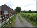
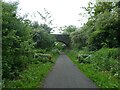
3
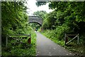
Bridge over the rail path
Looking along the rail path near the former Blacon station.
Image: © DS Pugh
Taken: 8 Aug 2020
0.12 miles
4
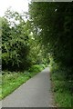
Cycle path near Blacon
Looking along part of the Chester rail path.
Image: © DS Pugh
Taken: 8 Aug 2020
0.12 miles
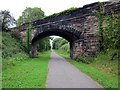
5
Egerton Road, Blacon, bridge over NCN5, Chester Railway Path
Image: © David Smith
Taken: 11 May 2023
0.13 miles
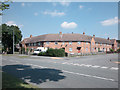
6

Access to Egerton Road from Chester Millennium Greenway
Image: © David Smith
Taken: 26 Apr 2024
0.17 miles
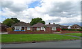
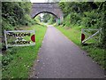
9
Blacon
A large residential area north west of Chester city centre.
Image: © Dennis Turner
Taken: 17 Aug 2005
0.19 miles