
IMAGES TAKEN NEAR TO
Arthur Street, CHESTER, CH1 4PG
Introduction
This page details the photographs taken nearby to Arthur Street, CH1 4PG by members of the Geograph project.
The Geograph project started in 2005 with the aim of publishing, organising and preserving representative images for every square kilometre of Great Britain, Ireland and the Isle of Man.

There are currently over 7.5m images from over14,400 individuals and you can help contribute to the project by visiting https://www.geograph.org.uk
Image Map
Images are licensed for reuse under creativecommons.org/licenses/by-sa/2.0
Notes
- Clicking on the map will re-center to the selected point.
- The higher the marker number, the further away the image location is from the centre of the postcode.
Image Listing (58 Images Found)
Images are licensed for reuse under creativecommons.org/licenses/by-sa/2.0
Image
Details
Distance

2
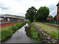
Finchett's Gutter
View from the bridge on Sealand Road.
Image: © JThomas
Taken: 15 Jun 2019
0.09 miles
5
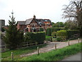
Houses at Chester sewage works
Pair of houses adjacent to the tanks at the sewage works.
Image: © John Haynes
Taken: 2 May 2012
0.12 miles
6
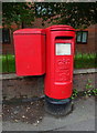
Elizabeth II postbox on Sealand Road, Chester
Postbox No. CH1 119.
Image: © JThomas
Taken: 15 Jun 2019
0.12 miles
8
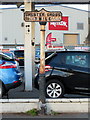
'Chester Cross 1 Mile' post in Sealand Road
This milepost stands alongside the A548, Sealand Road and is in need of repainting.
Cast iron post by the A548, in parish of CHESTER (CHESTER District), by car sales yard, on pavement, back to low wall, on North side of road. Chester Cross iron plate & post erected by the County Council in the 19th century. Inscription reads:- : CHESTER CROSS / 1 MILE / :
Listed.
Milestone Society National ID: CH_CHQF01.
National Survey of Wayside Features by The Milestone Society
These images are from Link
It was cast pre 1891 by R T Smith of Whitchurch, Salop.
Image: © John S Turner
Taken: 27 Dec 2017
0.15 miles
9
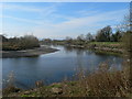
The river Dee near Cop Park
Bend in the river Dee north of the old dock area. This section of the Dee was canalised in the 1730's so that boats could navigate from Chester to the sea.
Image: © Eirian Evans
Taken: 1 Mar 2012
0.16 miles
10
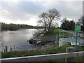
Finchett's Gutter Outfall into the River Dee
Looking south west along the tidal River Dee next to the Finchett's Gutter outfall. Over recent years all the drainage ditch outflows between Chester and the sea have been engineered so that high tides don't flood the surrounding low-lying land.
Image: © John S Turner
Taken: 23 Dec 2015
0.17 miles