IMAGES TAKEN NEAR TO
Finchett Drive, CHESTER, CH1 4DP
Introduction
This page details the photographs taken nearby to Finchett Drive, CH1 4DP by members of the Geograph project.
The Geograph project started in 2005 with the aim of publishing, organising and preserving representative images for every square kilometre of Great Britain, Ireland and the Isle of Man.

There are currently over 7.5m images from over14,400 individuals and you can help contribute to the project by visiting https://www.geograph.org.uk
Image Map
Images are licensed for reuse under creativecommons.org/licenses/by-sa/2.0
Notes
- Clicking on the map will re-center to the selected point.
- The higher the marker number, the further away the image location is from the centre of the postcode.
Image Listing (92 Images Found)
Images are licensed for reuse under creativecommons.org/licenses/by-sa/2.0
Image
Details
Distance
1
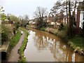
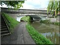
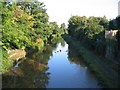
Shropshire Union Canal, Chester
A view of the canal from the bridge at Cheyney Road; looking towards the city centre.
Image: © David Dixon
Taken: 15 Apr 2016
0.14 miles
3
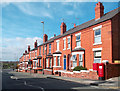
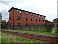
Cheyney Road, Chester
Red Brick terrace houses, typical of this part of town.
Image: © Des Blenkinsopp
Taken: 20 Mar 2012
0.15 miles
4
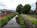
Finchett's Gutter
View from the bridge on Sealand Road.
Image: © JThomas
Taken: 15 Jun 2019
0.15 miles
5
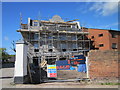
New Build in Upper Cambrian Road, Chester
At first glance I thought this was a renovation project but Google Streetview shows this as previously an empty strip of land where possibly an earlier house once stood. This new building appears to be Georgian style, much more pleasing than the 1980's apartments to the right.
Image: © Jeff Buck
Taken: 11 May 2015
0.15 miles
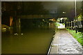
6
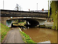
Cheyney Road bridge over Shrophire Union Canal, Chester
Image: © David Smith
Taken: 11 May 2023
0.15 miles
7
Stone Bridge #128, Shropshire Union Canal
Image: © David Dixon
Taken: 15 Apr 2016
0.16 miles
9
Shropshire Union Canal north from Cambrian Road footbridge
A view of the Shropshire Union Canal in the direction of Ellesmere Port from the Cambrian Road footbridge.
Image: © John S Turner
Taken: 29 Sep 2008
0.16 miles
10
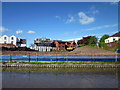
Development site on Upper Cambrian Road, Chester
This development site which has been a patch of wasteland for a number of years, is flanked by the Shropshire Union Canal (in the foreground), and Upper Cambrian Road.
Image: © Jeff Buck
Taken: 11 May 2015
0.16 miles