IMAGES TAKEN NEAR TO
Saughall Road, CHESTER, CH1 4BH
Introduction
This page details the photographs taken nearby to Saughall Road, CH1 4BH by members of the Geograph project.
The Geograph project started in 2005 with the aim of publishing, organising and preserving representative images for every square kilometre of Great Britain, Ireland and the Isle of Man.

There are currently over 7.5m images from over14,400 individuals and you can help contribute to the project by visiting https://www.geograph.org.uk
Image Map
Images are licensed for reuse under creativecommons.org/licenses/by-sa/2.0
Notes
- Clicking on the map will re-center to the selected point.
- The higher the marker number, the further away the image location is from the centre of the postcode.
Image Listing (51 Images Found)
Images are licensed for reuse under creativecommons.org/licenses/by-sa/2.0
Image
Details
Distance
1
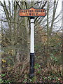
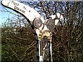
Old Milepost by Saughall Road, Chester
Cast iron milepost by Saughall Road, in the parish of CHESTER (CHESTER District), just southeast of the bridge over Backford Brook, and on the east side of Saughall Road. Chester Cross iron plate and post, cast pre 1891 by R T Smith of Whitchurch, Salop, and erected by the County Council in the 19th century. This is one of several posts alongside the main roads into Chester
Plate inscription reads:-
CHESTER CROSS
1 MILE
Column inscription reads:-
R T SMITH & CO
WHITCHURCH
Milestone Society National ID: CH_CHSL01
Image: © John S Turner
Taken: 25 Nov 2019
0.05 miles
2
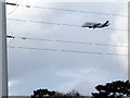
Airbus Beluga #5 approaching Hawarden Airport
This zoomed photograph shows the Airbus Beluga #5 approaching Hawarden airport. It is approximately 2km away over Mollington Grange at this moment, and nowhere near the power lines that are in the foreground, close to the A5480.
Image: © John S Turner
Taken: 18 Feb 2014
0.07 miles
3
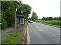
Bus stop and shelter on Saughall Road, Chester
Image: © JThomas
Taken: 15 Jun 2019
0.07 miles
4
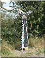
Colourful Milepost
Variation on the black theme of the National Cycle Network mileposts. This sign is at SJ397676 on Route 5.
Image: © Dennis Turner
Taken: 17 Aug 2005
0.08 miles
5
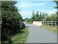
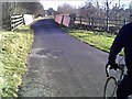
Cycleway Bridge
The original trackbed of the railway line on which this section of the Millennium cycleway was built, was on a high embankment at this point until the Deva Link road was built. The road link penetrated the embankment and this high level bridge was built.
Image: © Dennis Turner
Taken: 17 Aug 2005
0.08 miles
7
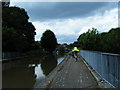
Shropshire Union Canal near Chester
The Shropshire Union Canal runs from near Wolverhampton to Ellesmere Port. This photo was taken from underneath bridge number 128b, close to Chester city centre.
Image: © David Quinn
Taken: 22 Aug 2007
0.08 miles
8
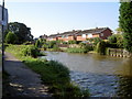
Deva Aqueduct on the Shropshire Union Canal
Carrying the canal across the A5480 in Chester.
Image: © Mat Fascione
Taken: 14 Apr 2019
0.08 miles
9
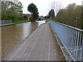
Chester Millennium Cycleway
Cycleway near Chester
Image: © chestertouristcom
Taken: 23 Jan 2005
0.09 miles
10
Chester Millennium Cycleway
Signpost on the cycleway
Image: © chestertouristcom
Taken: 23 Jan 2005
0.09 miles