
IMAGES TAKEN NEAR TO
Grey Friars, CHESTER, CH1 2NW
Introduction
This page details the photographs taken nearby to Grey Friars, CH1 2NW by members of the Geograph project.
The Geograph project started in 2005 with the aim of publishing, organising and preserving representative images for every square kilometre of Great Britain, Ireland and the Isle of Man.

There are currently over 7.5m images from over14,400 individuals and you can help contribute to the project by visiting https://www.geograph.org.uk
Image Map
Images are licensed for reuse under creativecommons.org/licenses/by-sa/2.0
Notes
- Clicking on the map will re-center to the selected point.
- The higher the marker number, the further away the image location is from the centre of the postcode.
Image Listing (1138 Images Found)
Images are licensed for reuse under creativecommons.org/licenses/by-sa/2.0
Image
Details
Distance
1

Junction of Nun's Road and Grey Friars, Chester
This area of Chester was occupied by the lands of the Benedictine Nunnery of St. Mary's and of the neighbouring houses of the Black, White and Grey Friars. Grey Friars is on the right of the building.
Image: © Jeff Buck
Taken: 10 Mar 2015
0.01 miles
2

OS benchmark - Chester, Nuns Road
A cutmark in the sandstone blockwork on the SW side of Nuns Road, originally levelled at 16.389m above Ordnance Datum Newlyn.
Image: © Richard Law
Taken: 21 Jul 2013
0.01 miles
3

Bench mark on the City Walls in Nuns Road
A cut bench mark in good condition on the city walls close to one of the entrances to the racecourse stands.
Image: © John S Turner
Taken: 23 Jun 2009
0.02 miles
4
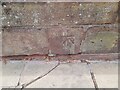
Ordnance Survey Cut Mark
This OS cut mark can be found on the City Walls. It marks a point 16.389m above mean sea level.
Image: © Adrian Dust
Taken: 13 Sep 2022
0.02 miles
5
![Chester Racecourse [3]](https://s0.geograph.org.uk/geophotos/04/53/51/4535132_ee8096d6_120x120.jpg)
Chester Racecourse [3]
Gate 7 gives entry to the racecourse from Nuns Road.
Image: © Michael Dibb
Taken: 6 Jun 2015
0.02 miles
6

Nun's Road, Chester
Nun's road approaching the Watergate.
Image: © Jeff Buck
Taken: 6 Jan 2010
0.03 miles
7
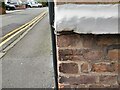
Ordnance Survey Cut Mark
This damaged OS cut mark can be found on No3 Greyfriars. It marks a point 17.636m above mean sea level.
Image: © Adrian Dust
Taken: 13 Sep 2022
0.03 miles
8
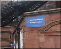
Alright lads - any dispute - this way.
Interesting signage as seen at the Chester Race course.
Image: © Richard Hoare
Taken: 11 Feb 2012
0.03 miles
9
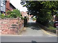
Grey Friars from Nuns Road
Looking along Grey Friars from Nuns Road. The religious establishments responsible for the naming of these roads have long since disappeared. The cars in the distance are on Nicholas Street.
Image: © John S Turner
Taken: 22 Aug 2007
0.04 miles
10
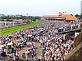
Chester Races
The crowds at Chester Races seen from Nuns Road.
Image: © Jeff Buck
Taken: 29 Jun 2019
0.04 miles