IMAGES TAKEN NEAR TO
Duke Street, CHESTER, CH1 1RP
Introduction
This page details the photographs taken nearby to Duke Street, CH1 1RP by members of the Geograph project.
The Geograph project started in 2005 with the aim of publishing, organising and preserving representative images for every square kilometre of Great Britain, Ireland and the Isle of Man.

There are currently over 7.5m images from over14,400 individuals and you can help contribute to the project by visiting https://www.geograph.org.uk
Image Map
Images are licensed for reuse under creativecommons.org/licenses/by-sa/2.0
Notes
- Clicking on the map will re-center to the selected point.
- The higher the marker number, the further away the image location is from the centre of the postcode.
Image Listing (2315 Images Found)
Images are licensed for reuse under creativecommons.org/licenses/by-sa/2.0
Image
Details
Distance
1
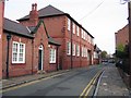
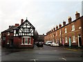
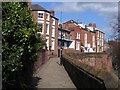
Duke Street and Bridgegate Chambers
Looking along the upper part of Duke Street towards the city walls, which are behind the line of parked cars. The small building on the left is The Bungalow, and the large building beyond that is Bridgegate Chambers.
Image: © John S Turner
Taken: 18 Oct 2007
0.01 miles
2
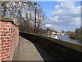
Chester's City Walls - Bridgegate to Eastgate #5
This next section of the city walls provides good views of The Groves, alongside the river, and the River Dee itself. In the distance is the suspension bridge that links The Groves and Handbridge.
The next photo in the series is taken from just around the next corner - see Image .
Image: © John S Turner
Taken: 14 Mar 2007
0.02 miles
3
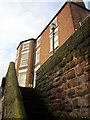
Recorder House, Chester
Recorder House at the top of the Recorder Steps on Chester City Walls.
Image: © Jeff Buck
Taken: 18 Jan 2014
0.02 miles
5
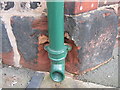
Damaged bench mark in Duke Street
The remains of a cut bench mark can be seen to the left of the drainpipe above the bracket. Only the horizontal line and the left leg of the arrowhead are still visible. On the right is the entrance to the Cheshire West and Chester Archives building, formerly a warehouse.
Image: © John S Turner
Taken: 30 Nov 2007
0.03 miles
6
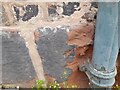
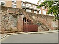
Ordnance Survey Cut Mark
This very damaged OS cut mark can be found on the warehouse SE side of Duke Street. It marks a point 17.621m above mean sea level.
Image: © Adrian Dust
Taken: 13 Sep 2022
0.03 miles
9
Chester's City Walls - Bridgegate to Eastgate #6
This view along the city walls shows an interesting group of buildings, which are part private and part hotel. Just around the next corner are the Recorder's Steps, which provide access to the Groves below for pedestrians only.
The next photo in this series is taken from the top of the Recorder's Steps - see Image
Image: © John S Turner
Taken: 14 Mar 2007
0.03 miles
10
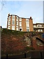
The Recorder's Steps, The Groves, Chester
Listed Grade I (list entry 1376170), the steps to the city wall were built 1820-22 for Roger Comberbach, City Recorder. They now have some unattractive structural support.
Image: © Stephen Craven
Taken: 24 Jun 2022
0.03 miles