
IMAGES TAKEN NEAR TO
St. Olave Street, CHESTER, CH1 1RJ
Introduction
This page details the photographs taken nearby to St. Olave Street, CH1 1RJ by members of the Geograph project.
The Geograph project started in 2005 with the aim of publishing, organising and preserving representative images for every square kilometre of Great Britain, Ireland and the Isle of Man.

There are currently over 7.5m images from over14,400 individuals and you can help contribute to the project by visiting https://www.geograph.org.uk
Image Map
Images are licensed for reuse under creativecommons.org/licenses/by-sa/2.0
Notes
- Clicking on the map will re-center to the selected point.
- The higher the marker number, the further away the image location is from the centre of the postcode.
Image Listing (2466 Images Found)
Images are licensed for reuse under creativecommons.org/licenses/by-sa/2.0
Image
Details
Distance
1

Ordnance Survey Cut Mark
This OS cut mark can be found on the north angle of the Christian Science Church. It marks a point 20.931m above mean sea level.
Image: © Adrian Dust
Taken: 13 Sep 2022
0.01 miles

3

Tudor House
A Grade II listed building dating back to the 1600s. Now used as a delicatessen.
Image: © Stephen Rogerson
Taken: 20 Aug 2012
0.01 miles
4

St Olave's Church
The east end of the former St Olave's Church. This small and ancient building ceased to be a church in 1841 when the parish was merged with St Michael's. St Michael's is itself now defunct - see Image The building has had many uses since 1841, and although it still seems secure there is no indication today of its current use. It stands to the side of this lane called St Olave's Street, but faces onto Lower Bridge Street in the distance.
Image: © John S Turner
Taken: 18 Oct 2007
0.02 miles
5

The Cross Keys on Lower Bridge Street
Image: © Steve Daniels
Taken: 30 Jul 2010
0.02 miles
6
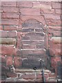
A Blocked Opening in St Olave's Church
This blocked opening in the north side of the ancient former church faces onto St Olave's Street. It seems too small to be a doorway and too high off the ground, and yet too low for a window. The building ceased to be a church in 1841.
Image: © John S Turner
Taken: 18 Oct 2007
0.02 miles
7

St Olave's Street
This old lane, which leads away from Bridge Street in the distance, provides access to various properties including the Christian Science Church, which is out of sight on the left. The old sandstone building is the former St Olave's church.
Image: © John S Turner
Taken: 18 Oct 2007
0.02 miles

9

St Olave Street, Chester
The church of the same name is off camera to the right. The building to the left, 53 Lower Bridge Street, is part medieval but largely rebuilt in the 18th/19th centuries, and listed grade II (list entry 1376311).
Image: © Stephen Craven
Taken: 24 Jun 2022
0.02 miles
10

St Olave's Street
This is the end of St Olave's Street furthest away from Lower Bridge Street - see also Image On the left is the entrance to the car park for Hotel Roma - see also Image On the right is the entrance to the Christian Science Church - see Image, and straight ahead are the backs of the houses in Steele Street - see Image
Image: © John S Turner
Taken: 20 Oct 2007
0.02 miles