IMAGES TAKEN NEAR TO
Love Street, CHESTER, CH1 1QN
Introduction
This page details the photographs taken nearby to Love Street, CH1 1QN by members of the Geograph project.
The Geograph project started in 2005 with the aim of publishing, organising and preserving representative images for every square kilometre of Great Britain, Ireland and the Isle of Man.

There are currently over 7.5m images from over14,400 individuals and you can help contribute to the project by visiting https://www.geograph.org.uk
Image Map
Images are licensed for reuse under creativecommons.org/licenses/by-sa/2.0
Notes
- Clicking on the map will re-center to the selected point.
- The higher the marker number, the further away the image location is from the centre of the postcode.
Image Listing (1758 Images Found)
Images are licensed for reuse under creativecommons.org/licenses/by-sa/2.0
Image
Details
Distance
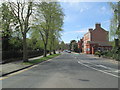
1
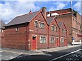
Cottages on Love Street
A block of three cottages, built in 1898, in Love Street, Chester. The large building on the right is the back of Brannigan's nightclub, formerly the ABC Regal cinema. Despite the lack of vehicles in the photo, Love Street is part of the very busy inner ring road. Priory Place is the junction on the left.
Image: © John S Turner
Taken: 28 Jun 2007
0.01 miles
2
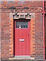
32 Love Street
The middle door of the three cottages seen at Image The sandstone lintel shows the construction date of 1898.
Image: © John S Turner
Taken: 28 Jun 2007
0.01 miles
3
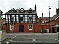
St John's Chambers, Union Street, Chester
Business premises, in the Victorian part-timbered style prevalent in the city.
Image: © Stephen Craven
Taken: 23 Jun 2022
0.01 miles
4
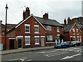
Buildings on Union Street, Chester
The house set back in the middle is a traditional bed-and-breakfast establishment called Park View.
Image: © Stephen Craven
Taken: 23 Jun 2022
0.01 miles
5
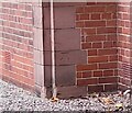
Ordnance Survey Cut Mark
This OS cut mark can be found on St John's Vicarage on Vicars Lane. It marks a point 20.254m above mean sea level.
Image: © Adrian Dust
Taken: 13 Sep 2022
0.02 miles
6
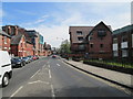
Union Street - viewed from Vicar's Lane
Image: © Betty Longbottom
Taken: 6 May 2013
0.02 miles
7
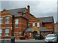
Grosvenor Park Academy, Union Street, Chester
A Church of England Primary School, previously known as University Church Free School, before that St Werburgh Middle School (at the time of listing in 1992) and originally Love Street School. Built 1909 for the City Council, architect H Beswick. Grade II listed, list entry 1375873
Image: © Stephen Craven
Taken: 25 Jun 2022
0.02 miles
8
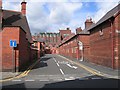
Priory Place off Love Street
Looking along Priory Place, which is a cul de sac leading off Love Street. The Victorian cottages are dwarfed by the office buildings behind.
Image: © John S Turner
Taken: 28 Jun 2007
0.03 miles
9
Vicar's Lane - viewed from Union Street
Image: © Betty Longbottom
Taken: 6 May 2013
0.03 miles
10
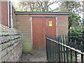
Electricity Substation - Union Street
Image: © Betty Longbottom
Taken: 6 May 2013
0.03 miles