IMAGES TAKEN NEAR TO
CF8 7JT
Introduction
This page details the photographs taken nearby to CF8 7JT by members of the Geograph project.
The Geograph project started in 2005 with the aim of publishing, organising and preserving representative images for every square kilometre of Great Britain, Ireland and the Isle of Man.

There are currently over 7.5m images from over14,400 individuals and you can help contribute to the project by visiting https://www.geograph.org.uk
Image Map
Images are licensed for reuse under creativecommons.org/licenses/by-sa/2.0
Notes
- Clicking on the map will re-center to the selected point.
- The higher the marker number, the further away the image location is from the centre of the postcode.
Image Listing (67 Images Found)
Images are licensed for reuse under creativecommons.org/licenses/by-sa/2.0
Image
Details
Distance
1
Hawthorn Avenue, Hengoed
Cul-de-sac on the west side of Hengoed Road.
Image: © Jaggery
Taken: 23 Aug 2019
0.04 miles
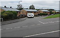
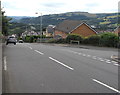
2
Traffic calming on Hengoed Road, Hengoed
Vehicles should stop behind the broken white lines if traffic is approaching.
Image: © Jaggery
Taken: 23 Aug 2019
0.04 miles
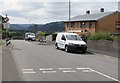
3
Warning sign - humps for half a mile, Hengoed Road, Hengoed
The sign on the ascent towards Cefn Hengoed is on the corner of Hawthorn Avenue. The text is also in Welsh.
Image: © Jaggery
Taken: 23 Aug 2019
0.04 miles
4
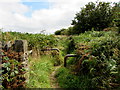
Metal barriers across a track from the east side of Hengoed Road, Hengoed
The barriers prevent vehicular misuse of the track.
Image: © Jaggery
Taken: 23 Aug 2019
0.05 miles
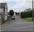
5
Junction of Hengoed Road and Hawthorn Avenue, Hengoed
Hawthorn Avenue joins Hengoed Road from the right.
Image: © Jaggery
Taken: 23 Aug 2019
0.05 miles
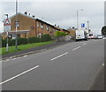
6
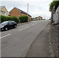
Up Hengoed Road, Hengoed
Part of the long ascent of Hengoed Road towards Cefn Hengoed viewed from the corner of Mount Pleasant.
Image: © Jaggery
Taken: 23 Aug 2019
0.06 miles
7
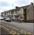
Row of stone houses, Chapel Terrace, Hengoed
On the west side of Hengoed Road.
Image: © Jaggery
Taken: 23 Aug 2019
0.06 miles
8
Acacia Avenue, Hengoed
From the west side of Hengoed Road, Acacia Avenue leads to Beech Drive and Myrtle Grove.
Image: © Jaggery
Taken: 23 Aug 2019
0.07 miles
9
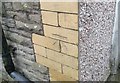
Ordnance Survey Cut Mark
This OS cut mark can be found on No6 Chapel Terrace. It marks a point 203.299m above mean sea level.
Image: © Adrian Dust
Taken: 8 Jun 2019
0.07 miles
10
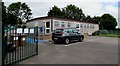
Flying Start, Hengoed
Located at the southern edge of Hengoed Primary school, Flying Start provides care for 26 children (morning and afternoon sessions). Flying Start is a Welsh Government funded programme available in targeted areas to support families to give children 3 years old and younger a flying start in life.
Image: © Jaggery
Taken: 23 Aug 2019
0.07 miles