1
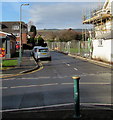
St Christopher's Close, Bedwas
On the west side of Church Street. In January 2019 scaffolding on the right is on the former Royal Oak. https://www.geograph.org.uk/photo/6035085
Image: © Jaggery
Taken: 25 Jan 2019
0.08 miles
2
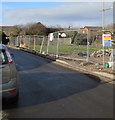
Fenced-off area in Bedwas
On the north side of St Christopher's Close at the edge of the former Royal Oak site on the corner of Church Street.
Image: © Jaggery
Taken: 25 Jan 2019
0.08 miles
3
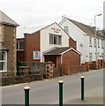
St Christopher's Close houses, Bedwas
West of Church Street.
Image: © Jaggery
Taken: 25 Jan 2019
0.08 miles
4
Bethel Baptist Church, Bedwas
Located on the west side of Church Street, opposite Hillside Terrace. Now much altered externally, the church was built in 1902-1903. Bethel Baptist Church is an independent Baptist church affiliated to the Evangelical Alliance.
Image: © Jaggery
Taken: 5 Mar 2011
0.08 miles
5
West along St Mary's Street, Bedwas
From Church Street. A National Grid van https://www.geograph.org.uk/photo/6035191 is on the left.
Image: © Jaggery
Taken: 25 Jan 2019
0.08 miles
6
Pandy Road, Bedwas
Image: © Robin Drayton
Taken: 17 Feb 2009
0.09 miles
7
National Grid van, St Mary's Street, Bedwas
The National Grid website states
"We are an international electricity and gas company based in the UK and northeastern US.
We play a vital role in connecting millions of people safely, reliably and efficiently to the energy they use."
Image: © Jaggery
Taken: 25 Jan 2019
0.10 miles
8
The Royal Oak Inn, Bedwas
Image: © John Lord
Taken: 12 Sep 2011
0.10 miles
9
Bethel Baptist Church, Church Street, Bedwas
A relatively modern building in a mainly early 20th century street.
Image: © Robin Drayton
Taken: 22 Aug 2008
0.10 miles
10
Post Office, Church Street, Bedwas
Image: © Robin Drayton
Taken: 22 Aug 2008
0.10 miles


