IMAGES TAKEN NEAR TO
Chatham Place, CAERPHILLY, CF83 8SG
Introduction
This page details the photographs taken nearby to Chatham Place, CF83 8SG by members of the Geograph project.
The Geograph project started in 2005 with the aim of publishing, organising and preserving representative images for every square kilometre of Great Britain, Ireland and the Isle of Man.

There are currently over 7.5m images from over14,400 individuals and you can help contribute to the project by visiting https://www.geograph.org.uk
Image Map
Images are licensed for reuse under creativecommons.org/licenses/by-sa/2.0
Notes
- Clicking on the map will re-center to the selected point.
- The higher the marker number, the further away the image location is from the centre of the postcode.
Image Listing (57 Images Found)
Images are licensed for reuse under creativecommons.org/licenses/by-sa/2.0
Image
Details
Distance
1
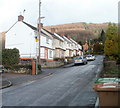
NE section of Llanarth Street, Chatham, Machen
View taken from about 100 metres NNE of Commercial Road (A468). The houses are located near a 90-degree bend in Llanarth Street ahead.
Image: © Jaggery
Taken: 14 Feb 2011
0.01 miles
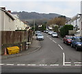
2
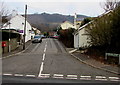
Chatham Street, Machen
Ascending from the A468 Chatham. The sign on the right shows that Chatham Street leads to Chatham Place.
Image: © Jaggery
Taken: 4 Jan 2019
0.01 miles
3
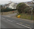
Speed camera sign, Chatham, Machen
Alongside the A468 Chatham near the corner of Chatham Street.
Image: © Jaggery
Taken: 4 Jan 2019
0.03 miles
4
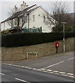
Queen Elizabeth II postbox, Chatham Street, Machen
On the left here. https://www.geograph.org.uk/photo/6016828
Image: © Jaggery
Taken: 4 Jan 2019
0.03 miles
5
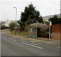
Chatham bus stop and shelter, Machen
The stop alongside the A468 Chatham is for buses to Newport.
Image: © Jaggery
Taken: 4 Jan 2019
0.03 miles
6
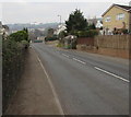
A468 Chatham, Machen
This part of the A468 is named Chatham. The Chatham Street junction https://www.geograph.org.uk/photo/6016828 is ahead on the right.
The wall on the left is above the Rhymney River.
Image: © Jaggery
Taken: 4 Jan 2019
0.03 miles
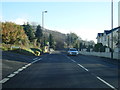
7
Llanarth Street, Machen
Ascending from the A468. Maps show the A468 Commercial Road
to the right of this junction and the A468 Chatham to the left.
Image: © Jaggery
Taken: 4 Jan 2019
0.03 miles
9
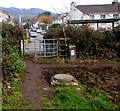
Kissing gate on the south side of the A468, Chatham, Machen
The gate gives walkers access to/from the public footpath through the field behind the camera.
Image: © Jaggery
Taken: 4 Jan 2019
0.05 miles
10
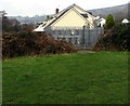
Western Power Distribution electricity substation, Chatham, Machen
Located at the edge of a field between the A468 and the Rhymney River.
The substation identifier is CHATHAM SW SITE S/S 541768
Image: © Jaggery
Taken: 4 Jan 2019
0.05 miles