IMAGES TAKEN NEAR TO
Penllwyn Lane, CAERPHILLY, CF83 8RR
Introduction
This page details the photographs taken nearby to Penllwyn Lane, CF83 8RR by members of the Geograph project.
The Geograph project started in 2005 with the aim of publishing, organising and preserving representative images for every square kilometre of Great Britain, Ireland and the Isle of Man.

There are currently over 7.5m images from over14,400 individuals and you can help contribute to the project by visiting https://www.geograph.org.uk
Image Map
Images are licensed for reuse under creativecommons.org/licenses/by-sa/2.0
Notes
- Clicking on the map will re-center to the selected point.
- The higher the marker number, the further away the image location is from the centre of the postcode.
Image Listing (6 Images Found)
Images are licensed for reuse under creativecommons.org/licenses/by-sa/2.0
Image
Details
Distance
1

Wooded hillside view from Addison Way, Graig-y-rhacca
Looking towards Coed Waun-cynllyfan.
Image: © Jaggery
Taken: 16 Aug 2018
0.12 miles
2
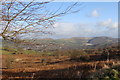
The Rhymney Valley towards Trethomas
Taken from Rudry Common car park.
Image: © Ruth Sharville
Taken: 4 Dec 2008
0.15 miles
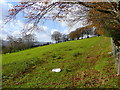
3
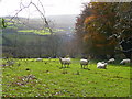
Sheep in pasture
Looking south over the Rhymney valley.
Image: © Jonathan Billinger
Taken: 11 Nov 2008
0.20 miles
4
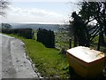
View from Pen-heol-machen
The lane descends to Machen, and the salt bin gives an indication of its steepness and exposure. The view is extensive; with the Bristol Channel glinting on the horizon.
Image: © Graham Horn
Taken: 21 Mar 2008
0.23 miles
5
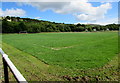
Football pitch in Graig-y-rhacca
Above Addison Way.
Image: © Jaggery
Taken: 16 Aug 2018
0.23 miles
6
Pastures north-west of Machen
The northern south-facing slopes of the Rhymney valley.
Image: © Jonathan Billinger
Taken: 11 Nov 2008
0.24 miles