IMAGES TAKEN NEAR TO
Commercial Road, CAERPHILLY, CF83 8QR
Introduction
This page details the photographs taken nearby to Commercial Road, CF83 8QR by members of the Geograph project.
The Geograph project started in 2005 with the aim of publishing, organising and preserving representative images for every square kilometre of Great Britain, Ireland and the Isle of Man.

There are currently over 7.5m images from over14,400 individuals and you can help contribute to the project by visiting https://www.geograph.org.uk
Image Map
Images are licensed for reuse under creativecommons.org/licenses/by-sa/2.0
Notes
- Clicking on the map will re-center to the selected point.
- The higher the marker number, the further away the image location is from the centre of the postcode.
Image Listing (188 Images Found)
Images are licensed for reuse under creativecommons.org/licenses/by-sa/2.0
Image
Details
Distance
1
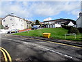
Dranllwyn Lane grit/salt box, Machen
The yellow box is near the street name sign showing that Dranllwyn Lane leads to Ty Canol Lane.
Image: © Jaggery
Taken: 14 Mar 2019
0.01 miles
2
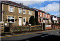
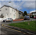
Housing variety in Machen
On the north side of the A468 Commercial Road.
Image: © Jaggery
Taken: 14 Mar 2019
0.01 miles
3
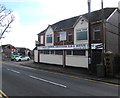
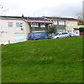
Machen Top Club
On the south side of the A468 Commercial Road. Three different names are in view in March 2019.
The largest sign shows MACHEN WORKMENS CONSTITUTIONAL CLUB & INSTITUTE LTD.
The rectangular sign above it shows Machen Top Club.
The sign on the left shows MACHEN WORKINGMENS CLUB & INSTITUTE LTD.
Image: © Jaggery
Taken: 14 Mar 2019
0.01 miles
4
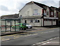
Bus stop and shelter near Machen Top Club
The stop on the south side of the A468 Commercial Road is for buses to Caerphilly via Trethomas and Bedwas. Machen Top Club https://www.geograph.org.uk/photo/6088004 is on the right.
Image: © Jaggery
Taken: 14 Mar 2019
0.01 miles
5
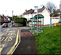
Machen Primary School bus stop and shelter
Located opposite Machen Primary School https://www.geograph.org.uk/photo/6088017 this stop on the corner of Dranllwyn Lane is for buses on Stagecoach Route 50 to Newport.
Image: © Jaggery
Taken: 14 Mar 2019
0.02 miles
6
No parking in Dranllwyn Lane, Machen
Double yellow lines on both sides of Dranllwyn Lane indicate no parking at any time.
Image: © Jaggery
Taken: 14 Mar 2019
0.02 miles
7
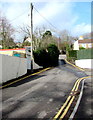
Llyswen, Machen
The cul-de-sac Llyswen ascends from Dranllwyn Lane.
Image: © Jaggery
Taken: 14 Mar 2019
0.02 miles
8
Bone Dry van in Llyswen, Machen
Text on the side of the van shows that Bone Dry is a plastering and plumbing maintenance business.
Image: © Jaggery
Taken: 14 Mar 2019
0.02 miles
9
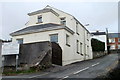
Siloam House, Machen
Detached house located on Siloam Hill, viewed from the corner of Commercial Road (A486).
The sign on the left is at the edge of a small car park alongside Commercial Road.
Image: © Jaggery
Taken: 26 Feb 2011
0.02 miles
10
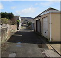
A back lane in Machen
Between the backs of Commercial Road houses on the left and houses in The Crescent on the right.
Image: © Jaggery
Taken: 14 Mar 2019
0.04 miles